Ma'agan Michael
Located on the Mediterranean Sea coast between Haifa and Hadera, it falls under the jurisdiction of Hof HaCarmel Regional Council.
The founding group was planning to settle on the seashore, motivated by the dream of establishing a Jewish fishing industry.
[6] Throughout the Mandate the British authorities and PICA attempted to enter into settlements with the local population,[clarification needed] and subsequently to remove them from the land.
[7] The PICA undertook land amelioration projects by draining the Kabbara marshes in the 1920s and foresting some parts of Barrat Qisarya, but the Arab population remained in place until the end of the Mandate period.
[5][8][9] The Kabarra swampland was drained in the 1920s with money from Baron Rothschild, and labor of Jewish pioneers and local Bedouin residents.
[7][8][9] The group which would eventually establish the settlement at its permanent location in 1949, first joined together in 1942, most of its members coming from the Hebrew Scouts.
[3] The group was originally based in a temporary Jewish Agency camp in Pardes Hanna, where they learned the skills needed to create an independent settlement, including how to manage citrus groves, cows, sheep, and chickens.
[3] During this period the kibbutz members lived a double life to keep information of the illicit arms factory from the British Mandate Forces.
[3] Ma'agan Michael was officially founded on 25 August 1949, when the first members began settling the present site by erecting there wooden huts prepared by carpenters in Rehovot.
[citation needed] On 11 March 1978, eleven Palestinian militants landed in Zodiac boats on a beach just outside Ma'agan Michael and from there ventured towards Tel Aviv in a hijacked bus in what has become known as the Coastal Road massacre where 38 Israelis were killed.
[citation needed] The kibbutz is located 30 km south of Haifa and 70 km north of Tel Aviv and lies near the edge of the Mediterranean Sea west of Mount Carmel, south of bordering kibbutz Ma'ayan Zvi, and north of the Taninim Stream.
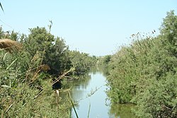
The nearby Timsah Springs, which originates from the Taninim Stream, is one of the local sources of brackish water for the kibbutz' numerous fishponds, which total 1,600 dunams (1.6 km2) in surface area.
[citation needed] A small area the Kabarra marshes, otherwise drained in the 1920s, remains swamplike and is used as pasture for horses and as a nature reserve.
[citation needed] MADAN is the Aquaculture Fish farming branch of kibbutz Ma’agan Michael agriculture enterprises.
There is also an area for intensive fish production in concrete ponds, which are used to raise almost 300 tons of striped bass, Musar, Lavrak.
[12] Muki Betser, a legendary commando officer, has founded a pre-military program (mechina) in the kibbutz, Mechinat Minsharim Kalu.