Mahasthangarh
The village Mahasthan in Shibganj upazila of Bogra District contains the remains of an ancient city which was called Pundranagara or Paundravardhanapura in the territory of Pundravardhana.
[1][2][3] A limestone slab bearing six lines in Prakrit in Brahmi script recording a land grant, discovered in 1931, dates Mahasthangarh to at least the 3rd century BCE.
Another reason for choosing this place was the position and size of the Karatoya, which as recently as in the 13th century was three times wider than Ganges.
[9] Mahasthangarh stands on the red soil of the Barind Tract which is slightly elevated within the largely alluvium area.
[2] Till the 1920s, when excavations started, the inside of the citadel was higher than the surrounding areas by over 4 metres and was dotted with several straggling elevated pieces of land.
Of these a few of note are: Jiat Kunda (well which, according to legends, has life giving power), Mankalir Dhap (place consecrated to Mankali), Parasuramer Basgriha (palace of a king named Parasuram), Bairagir Bhita (palace of a female anchorite), Khodar Pathar Bhita (place of stone bestowed by God), and Munir Ghon (a bastion).
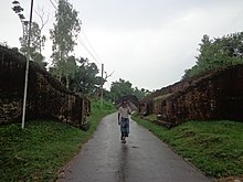
There are some gateways at different points: Kata Duar (in the north), Dorab Shah Toran (in the east), Burir Fatak (in the south), and Tamra Dawaza (in the west)[2] At the north-eastern corner there is a flight of steps (a later addition) that goes by the name of Jahajghata.
Excavation was carried out in 1960s around the Mazhar, Parasuramer Prasad, Mankalir Dhap, Jiat Kunda and in a part of the northern rampart.
In the next phase excavation was carried out sporadically in parts of the east and north ramparts but the final report is yet to be published.
An Arabic inscriptional slab of 1300–1301 discovered in 1911–12 mentions the erection of a tomb in honour of Numar Khan, who was a Meer-e-Bahar (lieutenant of the naval fleet).
[14] Khodarpathar Bhita: Some pieces of stone carved with transcendent Buddha along with devotees in anjali (kneeling with folded hands) recovered.
[14] Skandher Dhap: Situated in village Baghopara on the Bogra-Rangpur road, 3.5 km to the south of the citadel, a sandstone Kartika was found and structural vestiges of a damaged building were revealed.
It is believed to be the remains of Skandha Mandira (temple consecrated to Kartika), mentioned in Karatoya mahatmya, as well as Kalhan's Rajatarangin, written in 1149–50.
[14] Khulnar Dhap: Situated in village Chenghispur, 700 m west of the north-west corner of the citadel has revealed remains of a temple.
[14] From the present findings it can be deduced that there was a city called Pundravardhana at Mahasthangarh with a vast suburb around it, on all sides except the east, where the once mighty Karatoya used to flow.
It is evident that the suburbs of Pundravardhana extended at least to Baghopara on the south-west, Gokul on the south, Vamanpara on the west, and Sekendrabad on the north.
[16] Bhimer Jangal This well-known embankment starts from the north-east corner of Bogra town and proceeds northwards for about 30 miles to a marshy place called Damukdaher bit, under police station Govindaganj (Gaibandha District) and it is said, goes oil to Ghoraghat.
which merges in the Kalidaha bil; north of Mahasthan-garh O'Donnell was probably right in saying that the Subil represents the western of the two branches into which the Karatoya divided above Mahasthan.
The Bhima to whom the embankment is ascribed may be the Kaivarta chief of the eleventh century who according to the Ramcharitam ruled over Varendra in succession to his father Rudraka and uncle Divyoka, who had ousted king Mahipala II of the Pala, dynasty.
One of them called Dharmma-dungi, bears a brick inscription, reading scrvva-siddha sana 1148 Sri Suphala ... (the year =1741 A.D.).
Over the entrance is a brick inscription reading 1089 Meher Natha sadaka sri Abhirama Mehetara (the year =1681 A.D.).
This Silvan may possibly be the same as king Salavahan, son of Sahila-deva of the Chamba inscription who won the title of Kari-ghata-varsha (= hunjara-ghata-varsha ?)
[citation needed] Rojakpur Proceeding westward along the road from Gokul to Haripur, we pass into the western arm of the latter village, already referred to.
West of Haripur and south of the Somrai bil is the village of Rojakpur, into which, as already stated, the elevated ground from Chandnia hat extends.
[17] There is a local legend that Shah Sultan Balkhi Mahisawar arrived at Pundravardhana in the garb of a fakir (mystic holy pedlar of Islamic philosophy) riding a fish.
A scavenger Harapala informed Mahisawar that it was difficult to defeat the royal troops because of the pool called Jiat Kunda.
[8] In neighbouring West Bengal, the ruins of Dihar at Bishnupur subdivision of Bankura district date back to the 2700 BC.
The ruins of Pandu Rajar Dhibi on the banks of the Ajay River in Bardhaman district also date back to 2000 BC.
However, this recent archaeological discovery has not yet been properly studied by outside experts and specialists in this field, and as such the historical value of many of the statements must be considered as uncertain.
[18] The ruins at Chandraketugarh in 24 Parganas South and Rajbadidanga in Murshidabad district date back to the early years of the Christian era.