Malin Head
Malin Head (Irish: Cionn Mhálanna)[1] is the most northerly point of mainland Ireland, located in the townland of Ardmalin[2] on the Inishowen peninsula in County Donegal.
[4] Ptolemy's Geography (2nd century AD) described a point called Βορειον (Boreion, "the northern") which probably referred to Malin Head.
[6] The very distinct shorelines show the changing relationship between the sea and the land from the time the glaciers began to melt, some 15,000 years ago.
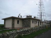
The RDF equipment was used by Allied naval and air forces to monitor U-boat and aerial activity in the North Atlantic.
[14] Malin Head is an ideal vantage point from which to view the autumnal movements of seabirds such as gannets, shearwaters, skuas, auks and others, on their southward migration flights.
This is also a good vantage point for viewing Basking sharks and the resident pod of Bottle-nosed Dolphins.