Mam Tor
Its name means "mother hill",[1] so called because frequent landslips on its eastern face have resulted in a multitude of "mini-hills" beneath it.
[6] A feature of Mam Tor is the active landslide which invades its southeast side almost to the summit, and interrupts the ramparts of the hillfort, unless its builders used it as part of the defences.
The landslide is due to weak shales underlying sandstones, a common phenomenon all around the Dark Peak, notably at Alport Castles, Longdendale, Glossop and Canyards Hills, Sheffield.
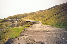
[7] Evidence for the continued movement of the slide mass is demonstrated graphically by the severe damage to the old Mam Tor road that traversed this flow.
A short tunnel could readily have been made avoiding the landslip zone, but the opportunity to exclude heavy business and lorry traffic from the middle of the National Park was preferred.
Current mean annual movement is "up to 0.25 m; this increases greatly when winter rainfalls exceed thresholds of both 210 mm/month and 750 mm in the preceding six months".