Manganese, Minnesota
It was built in Crow Wing County on the Cuyuna Iron Range in sections 23 and 28 of Wolford Township, about 2 miles (3 km) north of Trommald, Minnesota.
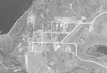
The community was composed of many immigrants who had fled the natural disasters and social and political upheavals in Europe during the decades before World War I. Manganese was laid out with three north–south and five east–west streets.
At its peak around 1919, Manganese had two hotels, a bank, two grocery stores, a barbershop, a show hall, and a two-room school, and housed a population of nearly 600.
After World War I, the population of Manganese went into steady decline as mining operations shut down; along with the quagmire of the clay streets due to spring rains, this led to the community's eventual abandonment and formal dissolution in 1961.
The area around Manganese, and modern-day Crow Wing County, was inhabited in the mid-to-late 1600s by three distinct populations of Native Americans vying for control of the lands that would become the Cuyuna Range.
This treaty secured Ojibwe hunting and fishing rights while ceding land which would become the Cuyuna Range to European-Americans looking to build new settlements in the region.
[4][5] The discovery of the Cuyuna Iron Range was an accident, made by the chance observation of a compass needle irregularity in 1895 while surveyor and mining engineer Cuyler Adams was exploring the area with his St. Bernard, named "Una".
Eight years after meticulously mapping these compass deflections, Adams performed test drilling in May 1903 which resulted in the discovery of manganiferous ore near Deerwood.
[10] Manganese was platted in sections 23 and 28 of Wolford Township by the Duluth Land and Timber Company on February 5, 1911,[11][12] established on March 13, 1912, and incorporated on November 10, 1913, with 960 acres (390 ha) inside the corporate limits.
[15] Hibbing, founded in 1893 and by 1915 the largest mining community on the Mesabi Range with a population of 20,000, was at one time called the "Iron Ore Capital of the World.
[12] In 1914, the town site had a crew of men and teams building streets with concrete sidewalks and curbing (although the clay roads were never paved).
By 1919, Manganese had two hotels, a bank, two grocery stores, two butcher shops, a lumber yard, a bakery, a livery stable, a barbershop, a pool room, a show hall, a dog pound, and a two-room school, and housed a population of nearly 600.
[37] The community was composed of many immigrants, including Finns, Croatians, Austrians, Swedes, Irish, Australians, English, Norwegians, Slovenians, and Serbs.
[13][25][41] Seven citizens from Manganese served in the military during World War I, including Harry Hosford,[42] who later survived the Milford mine disaster.
After the World War I armistice was signed, the demand for manganiferous ore decreased, and Manganese experienced a sharp drop in population from its peak of nearly 600 in 1919 to 183 in 1920.
Up to four Sunday school classes were offered depending on the ages of the children, and guest pastors would come to conduct services when occasional revival meetings were held.
Einer R. Anderson, then Crow Wing County Auditor, was appointed as its receiver, and creditors of the village of Manganese were given six months to file a claim.
Bids were accepted for the sale of the Manganese water tower and the frame building that had housed the village hall, with the condition that all debris be disposed of at the expense of the buyer.
[28][60] Willow, aspen, and other trees covered what was once a land occupied by numerous buildings; roots, shrubs, and grass began to heave and crack the concrete sidewalks and overtake the remaining grid pattern of roads, and the entire town site was consumed by the steady growth of natural vegetation.
[61] Called Manganese Base Camp, the old wooded lots, about 0.3 acres (0.12 ha) each, were being cleared and redeveloped as primitive campsites, without electricity, running water, or waste disposal services.
[63][69][70] The largest high-grade deposit of manganiferous ore is located about 14 miles (23 km) north of Manganese on a 5-acre (2.0 ha) site at the edge of Emily.