Mangerton Mountain
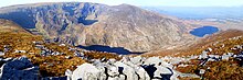
[4] The Horses' Glen (or Glencappul), and the Devil's Punchbowl carve deep hollows, or corries on the north-west and north-east sides of Mangerton's massif, but the southern flanks form a huge plateau, one of the most extensive areas of mountain wilderness in Ireland, where herds of red deer and sika deer still roam.
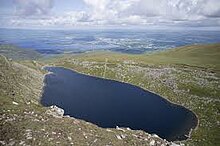
[4] The Devil's Punchbowl (Irish: Poll Ifrinn),[a] at 670 metres (2,200 ft) on Mangerton's north-west face is a deep oval-shaped corrie filled by a loch in its base that drains into the Owengarriff River from which Torc Waterfall is formed, before finally flowing into the Lakes of Killarney below.
[11] However, Mangerton's scale, summit views and deep corries are well regarded, and its proximity to Killarney town and ease of access are recognised by climbers.
[17] Despite the losses, the battle is considered a MacCarthy success as the Anglo-Normans were kept out of South Kerry and West Cork (i.e. the Kingdom of Desmond), for the next three centuries.
[2][4][17] In spite of such two-edged victories, the battle of Callann and Tuairin Cormaic, for good or for evil, effectually prevented the establishment of an Anglo-Norman rule in [The Kingdom of] Desmond.
It is that owing to dissensions among the Irish tribes the earls of Desmond eventually ' overtopped them all ', but in the region from which they drew their title they had more of the character of a Celtic chief than of a feudal lord, and it was left to the more resolute Tudor statesman and ruthless Tudor generals to break down the clan-system there.The MountainViews Online Database lists 26 Mangerton Mountain Group peaks more than 100 metres (330 ft) in height.