Territorial losses of Thailand
The concept of Thailand's territorial losses was first popularized in the 1930s as part of the anti-Western Thai nationalist ideology promoted by the government of Plaek Phibunsongkhram (Phibun).
The loss of territories was leveraged as a theme in "national humiliation discourse"—as termed by historian Shane Strate—which was employed to bolster support for the government and its irredentist ideology of Pan-Thaiism.
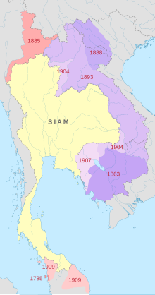
Several versions of the map exist, with differing accounting of the losses, but all include the cession of territory that is now Laos and Cambodia to the French in 1893, 1904 and 1907, and of the four Malay states to the British in 1909.
[3][7] Several other versions of the maps, especially the History of Thailand's Boundary, have also been produced, some by historians discussing the historical issues,[3] others by organizations or groups using them for political purposes, especially those surrounding territorial disputes with Cambodia.
[4] The depiction of the Altai Mountains origin theory suggests that the Historical Atlas was strongly influenced by Khun Wichitmatra's book Lak Thai, a popular account which became adopted into mid-20th century conventional historiography.
[3] Charnvit Kasetsiri has mentioned Thongbai's atlas as an example of how outdated concepts are still perpetuated by school textbooks, allowing nationalist sentiments to be stoked up by political groups.
[8] The concept remains a mainstay in Thai nationalist discourse, and has re-emerged especially along with the Preah Vihear dispute, which itself has become regarded as one of the losses in the recent versions of the map and list that proliferated in the 21st century.