Marble Arch Caves
[7] As early as the 1730s, the Reverend William Henry described these features, as well as the sinks of the Owenbrean, Aghinrawn and Sruh Croppa rivers which he correctly surmised to be feeders of the system.
[8] Without venturing far into the cave, Henry descended to the base of one of the dolines above the resurgence: The arch over my head was 20 feet high, continued with a little landing for 100 yards to the other great pit, by the light of which I could observe the river flowing gently along...
[9] Using a canvas boat, and with candles and magnesium flares for light, Martel and Jameson found 300 metres (1,000 ft) of passages,[10] including the junction where the three rivers (the Owenbrean and the combined Aghinrawn and Sruh Croppa) meet.
[NB 1][4] They drew a map of the discoveries and line drawings depicting the expedition, noting the upstream conclusion by boat in the Grand Gallery, and on foot at Pool Chamber.
[7] Martel and Jameson also investigated Cradle Hole, a very large surface shakehole 400 metres (1⁄4 mi) south-south-west of Marble Arch.
A group of cavers descended a pothole located close to the large dolines on the plateau and discovered the Great Boulder Chamber.
[7] When club members returned again in 1938 they brought an inflatable dinghy, allowing them to progress across the lake, only to discover that the way on was blocked by Sump 1, just 40 metres (132 ft) from the shore.
In December 1966 divers Dave Cobley and Mike Boon made preparations to dive Sump 1 in Skreen Hill passage.
Before making the dive however, they investigated a small dry passage leading off on the left bank of the lake, finding it to be blocked at the end by unstable boulders in the roof.
[18] The upstream continuation of the river in Skreen Hill 2 was found to be shortly blocked by Sump 3, so in March 1967 a team of divers returned to attempt further exploration.
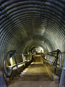
From 1982 until after opening in 1985, sections of Marble Arch Cave underwent development to improve accessibility in order to accept tourist visitors.
As well as concrete pathways, safety barriers and electric lighting, this involved installing weirs and jetties for boat access to enable visitors to enter the caves by the same route that Martel and the early explorers took.
They were in a group of ten cavers, mostly students from University College Dublin and Dublin Institute of Technology caving clubs, when the three were swept away by fast running water and drowned in the low air-space (or "duck", (which was flooded to the roof on this particular occasion) section of passage between the end of Lower Cradle Hole and the Grand Gallery in Marble Arch Cave.
Kozłowski made the first connecting dive to Prod's Pot – Cascades Rising, doubling the total length of the system from 4.5 to 9 km (2.8 to 5.6 mi).
[2] The Marble Arch Cave system is chiefly formed from three rivers which drain off the Marlbank area on the north side of Cuilcagh mountain.
In 2008 the park boundaries were extended across the border into parts of County Cavan in the Republic of Ireland, making it the first international Geopark in the world.
It was then sent to the Ulster Museum in Belfast where a calcite resin was specially produced and subsequently used to stick the tip back onto its original position.