Mariupol
Historically, the city of Mariupol was a centre for trade and manufacturing, and played a key role in the development of higher education and many businesses and also served as a coastal resort on the Sea of Azov.
[8] On 16 May 2022, the last Ukrainian troops who remained in Mariupol surrendered at the Azovstal Iron and Steel Works, and the Russian military secured complete control over the city by 20 May.
[10] From the 12th through the 16th century, the area around Mariupol was largely devastated and depopulated by intense conflict between the Crimean Tatars, the Nogay Horde, the Grand Duchy of Lithuania, and Muscovy.
East of the Dnieper River a desolate steppe stretched to the Sea of Azov, where lack of water made early settlement precarious.
Below the Dnieper Rapids were the Zaporozhian Cossacks, freebooters organized into small, loosely-knit, and highly mobile groups who were both livestock farmers and nomads.
Their independence from governmental and landowner authority attracted to join them many peasants and serfs fleeing the Polish–Lithuanian Commonwealth and Grand Duchy of Moscow.
[citation needed] The Treaty of Constantinople in 1700 further isolated the region, as it stipulated that there should be no settlements or fortifications on the coast of the Azov Sea to the mouth of the Mius River.
In 1709, in response to a Cossack alliance with Sweden against Russia, Tsar Peter the Great ordered the liquidation of the Zaporozhian Sich, and their complete and permanent expulsion from the area.
[15] Upon their return, the Zaporozhian population in these lands was extremely sparse, so effort to establish a measure of control, they introduced a structure of districts or palankas.
[18] Sometime after 1738,[19][20] the treaties of Belgrade and Niš in 1739, in addition to the Russian-Turkish convention of 1741,[21] as well as the following likely concurrent land survey of 1743–1746 (resulting in the demarcation decree of 1746), the Zaporzhian Cossacks established a military outpost on "the high promontory on the right bank of the Kalmius river.
[23] The outpost was likely a modest structure in that it lay within the territory of the Ottoman Empire, and the erection of fortifications on the Sea of Azov was prohibited by the Treaty of Niš.
[citation needed] The last Tatar raid, launched in 1769, covered a vast area, overrunning the New Russian Province with a huge army in severe wintertime weather.
This action initiated the Dnieper fortified line (running from today's Zaporizhzhia to Novopetrovka),[26] thereby laying claim to the region, including the site of future Mariupol, from the Ottoman Empire.
In 1869, consuls and vice-consuls of Prussia, Sweden, Norway, Austria-Hungary, the Roman States, Italy, and France established their representative offices in Mariupol.
[33][34] After the construction of the railway line from Yuzovka (later Stalino and Donetsk) to Mariupol in 1882, much of the wheat grown in the Yekaterinoslav Governorate and coal from the Donets Basin were exported via the port of Mariupol (the second largest in the South Russian Empire after Odesa), which served as a key funding source for opening a hospital, public library, electric power station and urban water supply system.
The Germans shot approximately 10,000 inhabitants,[39][better source needed] sent nearly 50,000 young men and girls as forced laborers to Germany and deported 36,000 prisoners to concentration camps.
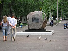
[41][42] The work consists of a seven-pointed menorah, a Star of David and two commemorative steles with inscriptions in Russian:[40][43] Victims of the fascist genocide were shot here – the Jews of Mariupol.
This unrest later evolved into the Russo-Ukrainian War between the Ukrainian government and Russia together with the separatist forces of the self-proclaimed Donetsk People's Republic (DPR).
[49][non-primary source needed] The city remained peaceful until the end of August 2014, when DPR separatists together with a detachment of the Russian Armed Forces captured Novoazovsk, located 45 kilometres (28 mi) east of Mariupol near the Russo-Ukrainian border.
[58] Russia "dramatically increased" the number of armed vessels in the Kerch Strait in 2018, and cargo ships bound for Mariupol found themselves subject to inspections by Russian authorities, resulting in delays of up to a week.
[82] In August 2023, the Institute for the Study of War reported that the Ukrainian Resistance Center had claimed to have gained access to documents detailing Russian plans to conduct a decade-long ethnic cleansing campaign in occupied Mariupol.
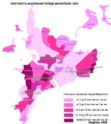
The city is mainly built on land made of solonetzic (sodium enriched) chernozem, with a significant amount of underground subsoil water, that frequently leads to landslides.
The city's leading enterprises have begun to address these ecological problems, so, over the last 15 years, industrial emissions have fallen to nearly a half of their previous levels.
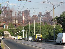
Ill-considered locations of the Azovstal and Markokhim to economize on transport charges, during both construction in the 1930s and subsequent operations, have led to extensive wind-borne emissions into the central areas of Mariupol.
This subdivision had already occurred in Crimea before the settlement of the Azov Sea steppe region by Pontic Greeks which began following the fall of the Empire of Trebizond in northeastern Anatolia in 1461.
Works of Mariupol poets and writers: N. Berilov, A. Belous, G. Moroz, A. Shapurmi, A. Savchenko, V. Kior, N. Harakoz, L. Kiryakov, L. Belozerova, P. Bessonov, and A. Zaruba are written in the Russian, Ukrainian, and Greek languages.
in honor of the Red Army, a fighting unit, a glorious deed or a hero who died in combat to liberate the country from the Third Reich, such as the monument to the twelve patriots shot by the Germans on 7 March 1942.
Old Mariupol is an area defined by the coast of the Sea of Azov to the south, the Kalmius River to the east, to the north by Shevchenko Boulevard, and to the west by Metalurhiv Avenue.
The central area of Mariupol (from Metalurhiv Avenue up to Budivelnykiv Avenue) is made up almost entirely of administrative and commercial buildings, including a city council building, a post office, the Lukov cinema, Mariupol State University of Humanities, Priazov State Technical University, the Korolenko central city library, and many large stores.
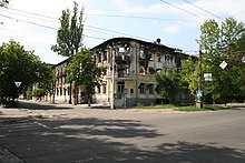
The architecture of other residential areas (Zakhidny, Skhidny, Kirov, Cheremushky, and 5th and 17th quarters) is not particularly distinctive or original and consists of typical apartment buildings of five to nine storeys.


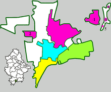
Populated places:
1 — Sartana
2 — Staryi Krym
3 — Talakivka
4 — Hnutove
5 — Lomakyne