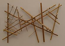
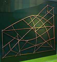
Marshall Islands stick chart
Stick charts were made and used by the Marshallese to navigate the Pacific Ocean by canoe off the coast of the Marshall Islands.
The use of stick charts ended after World War II when new electronic technologies made navigation more accessible and travel among islands by canoe lessened.
The stick charts are a significant contribution to the history of cartography because they represent a system of mapping ocean swells, which was never before accomplished.
They are generated by the northeast trade winds and are present during the entire year, even when they do not penetrate as far south as the Marshall Islands.
The stick charts typically fall into three main categories: mattang, meddo (or medo), and rebbelib (or rebbelith).
So that others could utilize the expertise of the navigator, fifteen or more canoes sailed together in a squadron, accompanied by a leader pilot skilled in use of the charts.
[3][4] Winkler had been the commander of the SMS Bussard, stationed in 1896 in the Marshall Islands which, during that period, were under German rule; he subsequently described the system in an 1898 publication.