E11 European long distance path
The melting ice in Northern Europe caused huge rivers to carve out wide valleys, whilst the sea level rose significantly and flooded low land.
It consists of a range of low mountain ridges (such as the Wiehen Hills and the Wesergebirge), created almost 100 million years ago from marine sediments which started to rise.
Nevertheless, the E11 links some interesting cities, such as The Hague, Amersfoort, Deventer, Osnabrück, Goslar, Luther's Wittenberg, Berlin, Frankfurt (Oder), Poznań, Gniezno, Toruń, Olsztyn, Lidzbark Warmiński and Kętrzyn.
[RNote 1] EUREGIO exploits the eastern part of the Marskramerpad and its continuation in Germany (together forming the stretch Deventer - Bad Bentheim - Osnabrück) under the name of Handelsweg.
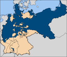
It crosses former West-Germany on a chain of ridges running from West to East, then passes the Harz Mountains without going higher than 514 meters, and finally gives an impression of the large-scale agrarian enterprises that were founded by the Brandenburg-Prussian nobility in the 17th century, and continued to exist in the form of People's Owned Companies during the GDR.
The Töddenweg (a regional name to be translated as Peddlers Way) used to begin in Oldenzaal in The Netherlands, but has its start now in Bad Bentheim, an old siege of German nobility with a medieval castle (partly museum) and a functioning spa.
Passing Eschershausen, medieval Alfeld (Leine), the Helleberg ("Mount Hell") and Bad Gandersheim, E11 reaches the Harz Mountains at the township of Seesen.
A further extension, long planned, but realized only in 2007, leads E11 through mining and large-scale agricultural country to the Natural Park of the Lower Saale (Naturpark Unteres Saaletal).
[RNote 6] Crossing Potsdam near the Central Railway Station takes little time as E11 avoids the interesting historical town center and the luxurious palaces of the former dukes of Brandenburg, who became kings of Prussia and emperors of Germany.
In Poland, E11 continues east, then northeast, to pass the cities of Międzychód, Poznań, Gniezno, Toruń, Brodnica, Iława, Olsztyn and Gołdap to the township of Ogrodniki, Sejny County on the Lithuanian border.
It dates back to 1934, when Nazi Germany began work on plans that had started under the democratic Weimar Republic, which wanted to defend itself against a possible attack from the East with a so-called Ostwall.
[RNote 14] The blue trail carries E11 on to the township of Gościkowo, where the Paradyż Abbey sometimes hosts tired ramblers overnight, provided they accept the sober rules of monk life.
After this point, E11 is not defined, but the obvious choice of a rambler interested in one of the oldest, biggest and most beautiful town centers along E11 is to turn right (South) toward Rynek Jezycki.
The quiet Northern shore of this Jezioro Maltańskie offers interesting views of the many sports accommodations on and around the lake and guides the E11 rambler to the zoo and the start of the well-marked but curving Cistercian bicycle track.
The trails now enter a large forest, leave the tar road after some kilometers and make a wide curve of 16 km to the village of Cierpice, the first of a chain of suburbs of Toruń.
[RNote 26] The historical city center of Olsztyn with its variety of museums, restaurants, theatres and hotspots for night life is without doubt a place where even the most fanatic E11 rambler wants to spend a day of rest.
Other buildings remind of the more recent, but also Roman Catholic past, for example the Palace of the bishops of Warmia at Smolajny, the monastery of Stoczek and the shrine of Święta Lipka.
The green trail passes through uninhabited woodland and should not be recommended to ramblers with a weak sense of orientation, or those who fear Russian red tape when crossing the border unintentionally and without visa.
In the stretch of the Nemunas between Alytus and Pakuonis, where the river forms several large loops with outcrops up to 40 m high, exceptionally picturesque landscapes abound.
Nemunaitis, like a majority of Lithuania’s small villages, features an impressive brick-and-stone church, while Alytus Castle-mound inhabited by ancient Lithuanians dates back to as early as the 14th century.
Multicoloured meadows of Lithuania’s most picturesque river valley (Vilkija - Dengtiltis, day 67 - 72) For a-day-and-a-half walk, the Forest Trail passes through Dubysa Regional Park (Dubysos regioninis parkas), where castle-mounds, historical churches and other testimonies of culture and history dot the riverbanks.
Highlights: rapid and clear waters of the river Dubysa and the deep valley, fortified castle-mounds and wooden crosses in Dubysa Regional Park, tallest and longest railway bridge in Lithuania, Šiluva — place of one of the first apparitions of Virgin Mary in Europe (1608), Tytuvėnai Regional Park — a land of lakes and forests, Tytuvėnai Monastery — among the most beautiful pilgrimage destinations in Lithuania.
The forest trail passes through the unique villages and towns of Žemaitija where people have preserved their dialect, customs and traditional holidays (Shrove Tuesday, Midsummer Night).
Highlights: Ostrich-watching in the vicinity of Snēpele, Pelči Manor and its fish ponds, lovely cats of the old town of Kuldīga, leisurely walk on the banks of the Alekšupīte, refreshing bathing by the waterfall (Ventas Rumba), historic brick bridge over the river Venta in Kuldīga, Riežupa sandstone caves — a maze with the greatest total length of underground passages in Latvia, waterfalls on the river Īvande at Renda.
In Sabile, you can taste ciders and wines brewed in the vicinity and beyond.The territory of Pedvāle Art Park (less than 100 hectares) features meadows, shrubs, rolling slopes, deep valleys, springs, streams and a winding river.
Highlights: beautiful avenues of manors and palaces, charm of roses at Tukums, Šlokenbeka Manor — medieval fortified dwelling, most forest-abundant section of the Forest Trail in Kurzeme, forests rich in mushrooms and berries, raised bogs and wetlands, historical resort park of Ķemeri, mirror-like surface of Lake Slokas and the observation tower, peaceful Gulf of Rīga.
Highlights: Park of Senses on the bluffs of the Gauja River – trail in the trees and barefoot trail in Valmiera city, The bridge over the Gauja River next to Strenči, Strenči – a town with ancient rafter traditions, Seda – a town built in socialist urban style, featuring classical architecture of Stalin’s era, Cirgaļi inland dunes and a viewing tower, Castle of Zvārtava – a Neogothic castle built in 1881, Trapene larch alley, Kalamecu - Markūzu ravines – magnificent ravines with waterfalls and a cave-like niche.
It winds through the Haanja Upland, Setomaa (Land of Setos) and along the western shore of Lake of Peipus until it reaches the Gulf of Finland in North Estonia, where it turns westwards.
Highlights: Haanja Nature Park – diverse landscapes and beautiful nature, Suur Munamägi viewing tower, Cafe at the highest peak in the Baltic states, Tradition of smoke sauna – UNESCO intangible cultural heritage, Nopri farm – local dairy producer, Vastseliina Bishop’s Castle Ruins and Pilgrim’s House, National Geographic yellow frames in the villages of Haanja and Vana-Vastseliina.
Lahemaa National Park, waterfalls, stones and cliff (Kuremäe – Tallinn, day 34 – 50) In the Northern Estonia section of the route, nature becomes harsher and increasingly Nordic.