Mont Pilat
[2] For a long time Mont Pilat designated the main mountain, with the double peaks or crests (crêts) of Perdrix and Oeillon.
[10] Pilat is separated from the Monts du Lyonnais to the north by the Saint-Étienne basin, the Gier valley.
[12] The river runs along the north side of the massif for 40.3 kilometres (25.0 mi) before joining the Rhone at Givors.
The Janon from Terrenoire (now part of Saint-Étienne) to Saint-Chamond and then the Gier from Saint-Chamond to Givors create a valley in the coal basin that runs between the Pilat massif and the Riverie chain of the Monts du Lyonnais.
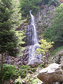
[14] Pilat has a wide variety of plants, reflecting different climate zones in a relatively small area.
Flint and pottery found in the municipality of Saint-Genest-Malifaux show that humans were present in pre-historic times.
They left many places of worship, arrangements of stones such as those at Château de Belize above Chuyer, the Rock Altar Roisey and La Garde, the sacred precincts of Saint-Sabin and the peak of the Three Teeth, and especially the "Menhir du Flat" near Colombier.
The water was collected above Saint-Chamond and routed through tunnels, of which there are remains at Chagnon and Saint-Martin-la-Plaine, and aqueducts such as the one at Chaponost.
The communes of the Communauté de communes des Monts du Pilat are Bourg-Argental, Burdignes, Colombier, Graix, Jonzieux, La Versanne, Le Bessat, Marlhes, Planfoy, Saint-Genest-Malifaux, Saint-Julien-Molin-Molette, Saint-Régis-du-Coin, Saint-Romain-les-Atheux, Saint-Sauveur-en-Rue, Tarentaise and Thélis-la-Combe.
[6] The region is attractive to motorcyclists, with winding roads leading through bright valleys and deep forests, and with magnificent views of the Alps and the Massif Central.
[19] It marked the meeting point of three provinces of Roman Gaul: Lyon, Narbonne and Aquitaine.