Mayflower line
The route is 11 miles 16 chains (18.02 km) in length from where it branches off the main line west of the town of Manningtree to its eastern terminus in Harwich.
It is part of Network Rail Strategic Route 7, SRS 07.07, and is classified as a London and South East commuter line.
[4] The track was doubled in 1882 by the GER, and the Manningtree North Curve which allows direct running between Ipswich and Harwich was also added at that time.
The War Department also had a munitions dump in Copperas Woods between Wrabness and Parkeston served by a spur which was situated on the north (river) side of the line just west of the point where the original alignment of the track to Dovercourt and Harwich Town had been changed when Parkeston was built.
By the late 1970s the cost of running the dated mechanical signalling systems north of Colchester was recognised and in 1978 a scheme for track rationalisation and re-signalling was submitted to the Department of Transport.
[7] In 1982 British Railways sectorised their operations and the branch fell under the London & South East (later renamed Network SouthEast in 1986).
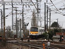
[5] East of Manningtree there is a triangular junction that enables trains operating to the port to reach the branch from both the north and south.
[10] Network Rail refer to this prototype model and its possible future descendants as Independently Powered Electric Multiple Units (IPEMU).