Meades Ranch Triangulation Station
From 1901, it was the reference location for establishing a system of horizontal measurement in the United States, known as geodetic datum.
The NAD27 was later supplanted by the North American Datum of 1983 (NAD83), which was formally adopted by the United States in 1989 and Canada in 1990; the new system moved the reference point to a point in the Earth's core, and the Meades Ranch marker lost its special significance to the geodetic datum system.
In 1973, the site was listed in the National Register of Historic Places as the Geodetic Center of the United States.
[2][7][8] In 1901, the Meades Ranch station was chosen as the United States standard horizontal datum: the point relative to which all land measurements in the nation were made.
The choice was based on the station's location near the geographic center of the U.S. and near the intersection of the two arcs of triangulation, and because it minimized the number of changes in previously published positions.
The new system continued to use the 1901 coordinates of Meades Ranch as its horizontal datum, and the Clarke spheroid as its model for the Earth's surface.
[4][5][6][9][10] In 1973, the Meades Ranch site was added to the National Register of Historic Places, under the name "Geodetic Center of the United States".
The relatively small number and large separation of the points used to develop NAD27, the limited computational power available to its designers, and the movement of tectonic plates also led to inconsistencies in NAD27 coordinates.
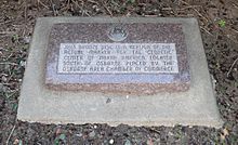
[17] A replica of the station marker, with a Kansas historical marker explaining its significance, is located at 39°27′08″N 98°41′37″W / 39.452286°N 98.693542°W / 39.452286; -98.693542 (Meades Ranch replica), in a roadside rest area beside U.S. Highway 281 at the northern edge of Osborne, Kansas, 18 miles (29 km) northwest of the Meades Ranch site.