Meare Pool
Meare Pool was formed by water ponding-up behind the raised peat bogs between the Wedmore and the Polden Hills, and core samples have shown that it is filled with at least 2 metres (6.6 ft) of detritus mud,[1] especially in the Subatlantic climatic period (1st millennium BC).
The pond would have extended no further west than the current Westhay to Wedmore road, where a shelf of rock formed a natural boundary.
[5] More recent studies have shown that the villages were formed by laying dried clay over the Sphagnum Moss of the bog.
[3] In the later years of the 12th century the Abbey diverted the Brue to flow westwards, perhaps largely through natural channels, from Meare Pool to join the river Parrett.
[7] Early drainage work was carried out in the later years of the 12th century, with the responsibility for maintaining all the watercourses between Glastonbury and the sea being placed on named individuals among whom were Ralph de Sancta Barbara of Brentmarsh.
[13] Drainage of the surrounding area by monks of Glastonbury Abbey had reduced the size of the lake to 500 acres (200 ha) at the time of the Dissolution of the Monasteries.
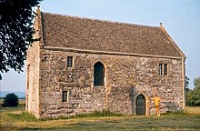
[14] The 14th-century fish house has been designated as a Grade I listed building and Scheduled Ancient Monument and is now in the care of English Heritage.