Medway Megaliths
The Medway Megaliths have become heavily damaged and dilapidated since original construction, largely due to an intentional program of destruction in the late 13th century CE.
[2] Either way, it certainly emerged through contact with continental Europe, probably as a result of centuries of interaction between Mesolithic people living in south-east Britain and Linear Pottery culture (LBK) communities in north-eastern France.
[4] Throughout most of Britain, there is little evidence of cereal or permanent dwellings from this period, leading archaeologists to believe that the Early Neolithic economy on the island was largely pastoral, relying on herding cattle, with people living a nomadic or semi-nomadic way of life.
[6] There is archaeological evidence of violence and warfare in Early Neolithic Britain from such sites as West Kennet Long Barrow and Hambledon Hill, with some groups constructing fortifications to defend themselves from attackers.
[9] It remains unclear to what extent the Kentish area was deforested in the Early Neolithic, although it appears that widespread forest clearance only took place on the chalklands of south-east Britain much later, in the Late Bronze Age.
The tombs provide the earliest and most tangible evidence of Neolithic people and their customs, and are some of the most impressive and aesthetically distinctive constructions of prehistoric Britain."
[12] The construction of these collective burial monumental tombs, both wooden and megalithic, began in continental Europe before being adopted in Britain in the first half of the fourth millennium BCE.
[12] Many archaeologists have suggested that this is because Early Neolithic people adhered to an ancestor cult that venerated the spirits of the dead, believing that they could intercede with the forces of nature for the benefit of their living descendants.
[18] Archaeologist Caroline Malone noted that the tombs would have served as one of a variety of markers in the landscape that conveyed information on "territory, political allegiance, ownership, and ancestors.
[21] Many archaeologists have suggested that the construction of such monuments reflects an attempt to stamp control and ownership over the land, thus representing a change in mindset brought about by Neolithicisation.
[25] Although now all in a ruinous state and not retaining their original appearance,[26] at the time of construction the Medway Megaliths would have been some of the largest and most visually imposing Early Neolithic funerary monuments in Britain.
[32] The BBC Countryfile website notes that although none of the monuments are on the same scale as Stonehenge, they are "really quite impressive" when taken collectively, describing them as "the east of England's answer to the megaliths of the Salisbury Plains".
[36] The chambers were constructed from sarsen, a dense, hard, and durable stone that occurs naturally throughout Kent, having formed out of silicified sand from the Eocene.
[44] Based on a stylistic analysis of their architectural designs, Stuart Piggott thought that they had originated in the area around the Low Countries,[45] while Glyn Daniel instead believed that the same evidence showed an influence from Scandinavia.
[66] The decision by the builders of these Stour Long-Barrows to avoid using stone as a building material was likely deliberate, for sarsens are naturally present in the local area and could have been obtained without too much trouble.
[77] In 1982, Robin Holgate published a paper in Archaeologia Cantiana in which he reassessed the stones in the context of contemporary thought as to megalithic archaeology in Britain.
[44] From October 1998 to March 1999, the company Oxford Archaeological Unit excavated the site around the White Horse Stone at the behest of Union Railways (South) (URS) in advance of the construction of the nearby Channel Tunnel Rail Link.
[88] In 1856, John Mitchell Kemble and the Reverend Lambert Larkin excavated at the site, reporting to the Central Committee of the British Archaeological Association that they had discovered sherds of pottery, some of which they suspected to be Anglo-Saxon in date.
[90] In 1910, F.J. Bennett undertook an excavation at the site, revealing the bones of 22 individuals, of both sexes and various ages, along with a pot sherd and a flint saw, which had been buried in the north-western part of the monument.
[103] The first unequivocal published mention of the Chesnuts Long Barrow was provided by antiquarian Josiah Colebrooke in 1773; he erroneously considered it to be a stone circle, describing it as one of "the temples of the antient [sic] Britons".
[104] In 1778 John Thorpe wrongly associated the monument with the ancient druids,[104] and it was not until 1863 that Charles Moore Jessop recognised that the stones had once been part of a chambered tomb.
[104] The site was excavated in 1957 by John Alexander at the behest of the Ancient Monuments Inspectorate of the Ministry of Works due to the construction of a house nearby.
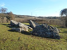
[102] Kit's Coty House represents the surviving remains of another chambered tomb, and has been described by archaeologist Timothy Champion as "perhaps the best-known monument in Kent".
[36] The long mound has eroded away, leaving only a dolmen on the eastern end of the monument, which consists of three large upright stones, with a fourth capstone on top.
[106] Traces of the mound and peristalith were identified in January 1982 during a measured survey by the Kent Archaeological Rescue Unit, in which they showed it to be 70m long, estimating that it was about 1m high.
[109][110] However, it was the discussion of the work in Camden's Britannia that resulted in it becoming more widely known and developing into a visitor's attraction; for instance, Samuel Pepys recorded his 1669 visit to the site in his diary.
[109] It attracted the interest of antiquarian John Aubrey, who wrote about it in his Monumenta Britannica, in which he included an image of the site drawn by classical scholar Thomas Gale.
[111] William Stukeley first visited the site in October 1722, making various drawings and plans of the monument, and would later publish his findings, albeit without reference to either Horsa or Catigern.
[120] In the 1840s, an antiquary and Druid from Maidstone, Beal Poste, published an account in which he asserted that a sack full of human bones was found in the vicinity of the Stone during the 1830s.
[124] The Upper White Horse Stone is located inside a narrow strip of woodland east of the A229 dual carriageway, and can be reached via the Pilgrim's Way track.