Merced Army Airfield auxiliary fields
In 1940 the US Army wanted to build near Merced, California a 30,000 per year basic pilot training base.
United States Army Air Corps leased the land from the City of Merced on 16 June 1941.
Building the airbase school started on 8 July 1941 and opened on 20 September 1941 as a sub-base of Army Air Forces Western Flying Training Command at Moffett Field.
The Merced Army Air Field runway was long enough and strengthened to handle training for Boeing B-29 Superfortress in 1944.
On 17 January 1946 the Merced Army Air Field was renamed Castle Field, after Brigadier General Frederick W. Castle, who on 24 December 1944, continued flying his B-17 Flying Fortress so his crew could bail out, he was killed when the aircraft exploded.
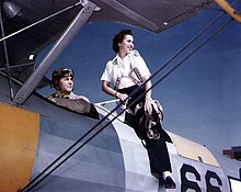
The other planes used at the fields were Boeing-Stearman Model 75 (called Kaydet) and North American T-6 Texan.
After the attack on Pearl Harbor on 7 December 1941, the US War Department leased the Airport to the US Army in 1942.
Temporary tents were put up for cadets and staff lived in the hangars and local hotels.
Some support buildings were built: stagehouse, crash truck shelter, a control tower, a storehouse, latrines, and sheds.
Parts of the vast base were sold off or leased to: Oliver Chance for agricultural, Golden By-Products for drying almond hulls, and the Ballico Resource Conservation District.
Due to poor water drainage, Howard Auxiliary Field was closed on 15 April 1944 and both leases canceled by 4 September 1944.
Merced Army Flying School used Athlone Auxiliary Field for training of pilots.
Potter Auxiliary Field was 18 miles southwest of the city of Merced, California.
The Army built a 3,000 by 3,000-foot landing mat, a stagehouse, crash truck shelter and latrines at the site.
The city received a 1940 Works Progress Administration project to graded, level and installed drainage for a new airport.
Merced Army Flying School on 7 April 1942 was authorized to build auxiliary airfields to support the training of pilots at the site.
The Army built a radio beacon nearby on Mount Bullion owned by the Bureau of Land Management in the 1940s.
For training the Army used the existing: 3,306 foot runway, hangar, gasoline fueling equipment, lighting, and cabin.
At an elevation of 2,254 feet the airfield was above the common San Joaquin valley fog layer, making at a good training and emergency landings.
[13] This article incorporates public domain material from the Air Force Historical Research Agency