Metacomet Ridge
It has been the focus of ongoing conservation efforts because of its natural, historic, and recreational value, involving municipal, state, and national agencies and nearly two dozen non-profit organizations.
[4] A 2004 report conducted for the National Park Service extends that definition to include the entire traprock ridge from Long Island Sound to the Pocumtuck Range in Greenfield, Massachusetts.
[10][11][12] The names Metacomet and King Philip have been applied to at least sixteen landscape features and over seventy-five businesses, schools, and civic organizations throughout southern New England.
[3][15] North of Mount Tom and the Holyoke Range, the apparent crest of the Metacomet Ridge is broken by a discontinuity in the once dominant traprock strata.
Mount Warner, 512 feet (156 m), in Hadley, Massachusetts, the only significant peak in the area, is a geologically unrelated metamorphic rock landform that extends west into the sedimentary strata.
From Greenfield north to Northfield, Massachusetts 2 miles (3 km) short of the Vermont–New Hampshire–Massachusetts tri-border, the profile of the Metacomet Ridge diminishes into a series of nondescript hills and low, wooded mountain peaks composed of sedimentary rock with dwindling traprock outcrops.
However, low parallel hills and related strata along much of the range often make the actual geologic breadth of the Metacomet Ridge wider than the more noticeable ridgeline crests, up to 10 miles (16 km) across in some areas.
[3] The Metacomet Ridge is surrounded by rural wooded, agricultural, and suburban landscapes, and is no more than 6 miles (10 km) from a number of urban hubs such as New Haven, Meriden, New Britain, Hartford, and Springfield.
Small city centers abutting the ridge include Greenfield, Northampton, Amherst, Holyoke, West Hartford, Farmington, Wallingford, and Hamden.
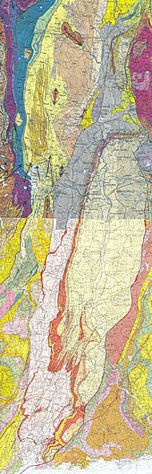
[3] The Metacomet Ridge is the result of continental rifting processes that took place 200 million years ago during the Triassic and Jurassic periods.
The basalt (also called traprock) crest of the Metacomet Ridge is the product of a series of massive lava flows hundreds of feet thick that welled up in faults created by the rifting apart of the North American continent from Eurasia and Africa.
The weathering of iron-bearing minerals within it results in a rusty brown color when exposed to air and water, lending it a distinct reddish or purple–red hue.
Backslope plant communities tend to be similar to the adjacent upland plateaus and nearby Appalachians, containing species common to the northern hardwood and oak-hickory forest ecosystem types.
Tracts of woodland in the river bottoms surrounding the ridges were sometimes burned to facilitate the cultivation of crops such as corn, squash, tobacco, and beans.
Hobbomuck is also credited with slaying a giant human-eating beaver who lived in a great lake that existed in the Connecticut River Valley of Massachusetts.
Steep terrain like the Metacomet Ridge, while not suitable for planting crops, was widely harvested of timber as a result of the expanding charcoal industry that boomed before the mining of coal from the mid–Appalachian regions replaced it as a source of fuel.
[25] With the advent of industrialization in the 19th century, riverways beneath the Metacomet Ridge were dammed to provide power as the labor force expanded in nearby cities and towns.
[1][21][26] Increased urbanization and industrialization in Europe and North America resulted in an opposing aesthetic transcendentalist movement characterized in New England by the art of Thomas Cole, Frederic Edwin Church, and other Hudson River School painters, the work of landscape architects such as Frederick Law Olmsted, and the writings of philosophers such as Henry David Thoreau and Ralph Waldo Emerson.
Estates became museums; old hotels and the lands they occupied, frequently subject to damaging fires, became state and municipal parkland through philanthropic donation, purchase, or confiscation for unpaid taxes.
[33][34][37] In the late 1950s, the 110 miles (180 km) Metacomet-Monadnock Trail was laid out by the Berkshire Chapter of the Appalachian Mountain Club under leadership of Professor Walter M. Banfield of the University of Massachusetts Amherst.
However, suburbanization through urban exodus and automobile culture, and modern construction techniques and equipment have created a demand for homes on and around the once undeveloped Metacomet Ridge and its surrounding exurban communities.
Considered an attractive place to build homes because of its views and proximity to urban centers and highways, the Metacomet Ridge has become a target for both developers and advocates of land conservation.
Quarrying, supported by the increased need for stone in local and regional construction projects, has been especially damaging to the ecosystem, public access, and visual landscape of the ridge.
[1] At the same time, the boom in interest in outdoor recreation in the latter 20th century has made the Metacomet Ridge an attractive "active leisure" resource.
[38] Several international and national organizations have also become interested in the Metacomet Ridge, including The Nature Conservancy, the Sierra Club, and the Trust for Public Land.
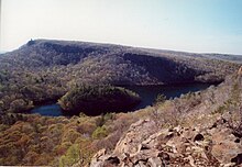
[9][39][40] Steepness, long cliff–top views, and proximity to urban areas make the Metacomet Ridge a significant regional outdoor recreation resource.
Museums, historic sites, interpretive centers, and other attractions can be found on or near the Metacomet Ridge; some offer outdoor concerts, celebrations, and festivals.
[1][3][43] The gigantic man-like profile of the Sleeping Giant, a traprock massif visible for more than 30 miles (50 km) in south central Connecticut, bears quarrying scars on its "head".
Ultimately signed by eighteen towns out of the nineteen ridge-line communities, this agreement committed local conservation commissions to strive to protect these ridges.