Sand Point and Middle Hope
Sand Point in Somerset, England, is the peninsula stretching out from Middle Hope, an 84.1-hectare (208-acre) biological and geological Site of Special Scientific Interest.
Some sources treat Sand Point as the lower limit of the Severn Estuary and its boundary with the Bristol Channel, although definitions of these areas vary and are often ambiguous.
The underlying geology and soil types support scarce plants such as the smallflower buttercup, honewort, Cheddar pink and Somerset hair grass.
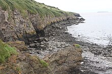
At Middle Hope a sequence of carboniferous limestone is exposed, which includes thick volcanic tuffs and lavas, demonstrating Tournaisian carbonate sections.
[7] The raised beach of wave-cut platforms has been created by changes in sea level of the Bristol Channel since the Quaternary period.
The calcareous grassland is dominated by Festuca species and Dactylis glomerata, while the scrub towards the west of the site is dominated by hawthorn (Crataegus monogyna) and blackthorn (Prunus spinosa), while that to the east consists of common gorse (Ulex europaeus) and bramble (Rubus fruticosus agg).
[4] Less common plants include the cheddar pink (Dianthus gratianopolitanus) and Somerset hair grass (Koeleria vallesiana).
[26] In 1969 the priory was taken over by the Landmark Trust who spent 20 years on restoration work, and since the 1990s have rented out the farmhouse as holiday accommodation.
[4] In 1968 the priory and adjoining land of Middle Hope was purchased by the National Trust for Places of Historic Interest or Natural Beauty as part of Project Neptune.