Mistelgau
Roughly 5 km southwest of the main town, but still within the municipality, lies Neubürg, a table hill offering views of the surrounding area.
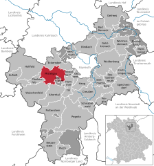
Beginning in the north and continuing clockwise, Mistelgau shares borders with the following municipalities: Eckersdorf, Mistelbach, Hummeltal, Glashütten, Plankenfels, Hollfeld, and Thurnau.
[4] The municipality consists of the following 42 districts: Äußerer Graben, Außerleithen, Bärnreuth, Böhnershof, Braunersberg, Culm (obere), Culm (untere), Engelmeß, Eschenmühle, Frankenhaag, Friedrichsruh, Geislareuth, Gollenbach, Göritzen, Gries, Hardt, Harloh, Hundshof, Kammer, Klingenmühle, Kreckenmühle, Laimen, Lenz, Mengersdorf, Mistelgau, Moosing, Obernsees, Ochsenholz, Pensenleithen, Plösen, Schnackenwöhr, Schobertsberg, Schobertsreuth, Schöchleins, Seitenbach, Sorg, Streit, Striegelhof, Tennig, Truppach, Wohnsgehaig.
[5] Source:[3] The area of the current municipality was first populated during the Stone Age: on top of the Neubürg, a fortified settlement existed between the Neolithic and the La Tène period.
During the Napoleonic Wars, a part of the municipality served as a staging area for French artillery in a battle against the Austrians (1806).
After the Treaties of Tilsit, Mistelgau was briefly under French control until the Kingdom of Bavaria purchased it alongside the remainder of the former Principality of Bayreuth.
In 1904, a railroad line from Bayreuth to Hollfeld (see main article: Bayreuth–Hollfeld railway) with a stop in the village of Mistelgau was opened.
In 1972, several other formerly independent municipalities (Seitenbach, Engelmeß, Truppach, Mengersdorf, Frankenhaag, Plösen, Gollenbach, Wohnsgehaig) were incorporated into Mistelgau.