Mitchell Freeway
Further works are planned, which will eventually take the freeway past Yanchep and Two Rocks to the boundary of the Perth metropolitan region.
It commences at the northern end of the Narrows Bridge, Perth, continuing from Kwinana Freeway, and terminates north of the satellite city of Joondalup at Romeo Road, Alkimos.
This is a hybrid interchange connecting the freeway with Mounts Bay Road and Riverside Drive, over a distance of 800 metres (2,600 ft).
The southbound exit ramp is similarly shared, before diverging for three destinations: Mounts Bay Road, Riverside Drive, and the Perth Convention and Exhibition Centre car park.
After this, it turns north-easterly for 500 metres (1,600 ft),[6] and lines up with the city blocks between George and Elder streets, a pair of one way frontage roads.
The freeway continues north, now within the City of Stirling LGA, through Osborne Park, until it reaches Hutton Street after 2.4 kilometres (1.5 mi).
[6] There are several local roads in Osborne Park that have T-Junction intersections with the freeway ramps south of Hutton Street.
There are slight modifications to the entrance and exit ramps between these roads, which merge for 500 metres (0.31 mi), requiring traffic to weave.
Beyond Erindale Road, the suburb to the east of the freeway is Balcatta, and 1.3 kilometres (0.8 mi)[6] further north is Reid Highway, with the southbound and westbound-to-northbound entry ramps looped.
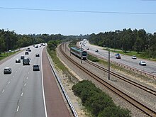
Each interchange also provides access for the railway stations in the median (Greenwood and Whitfords respectively) via the southbound entry ramps, which are two-way north of the carparks' entrances.
350 metres (1,150 ft)[6] north of the Shenton Avenue interchange, the railway line re-enters the freeway median just prior to passing under Moore Drive.
Both the freeway and railway then pass over Burns Beach Road, 1 kilometre (0.6 mi)[6] further north with the Currambine station lying 200 metres (660 ft) to the south.
[10] However, the first gazetted edition of the Metropolitan Region Scheme, from 1963, shows a controlled-access highway along the current freeway alignment.
[12] The later plan only detailed the route up until a point east of Sorrento, at a proposed east-west controlled-access highway on the modern day Hepburn Avenue alignment.
[12] Detailed design on the first stage of the freeway, from the Narrows Bridge to Sutherland Street at the northern edge of the city, began in 1960, and took several years to be completed.
[11]: 187–9 Ground improvement works, which included the installations of 43,000 sand drains, began in 1964;[11]: 189 demolition of buildings in the freeway's path commenced in 1965.
[11]: 219 This initial section functioned only as a distributor for Narrows Bridge traffic accessing Perth's central business district or adjacent areas to the north-west.
Stage 5 was from Erindale to Warwick Road, and involved excavating a large quantity of material, including 600,000 tonnes (1.3 billion pounds) of limestone.
[18] A further extension to Ocean Reef Road was opened on 2 July 1988 by the Federal Minister for Transport, Peter Morris,[24] at a cost of $17.5 million.
[11]: 309–10 In 1991 and 1992,[18] the median strip of the entire freeway was significantly widened to accommodate the Yanchep line, being built under the Northern Suburbs Transit System project.
[25] After a 7-year-hiatus, a 3-kilometre (1.9 mi) extension to Hodges Drive was opened by Premier Richard Court in December 1999, two months ahead of schedule.
[26][27] After another 7-year-hiatus, construction began on a 4-kilometre extension to Burns Beach Road, with a diamond interchange at Shenton Avenue and an overpass for Moore Drive.
[28] Local residents were opposed to aspects of the initial plans, such as the design of a section near a primary school and the clearing of native vegetation.
[34] In its 2011/12 budget, the State Government committed $30 million for the widening of the Mitchell Freeway northbound between Hepburn Avenue and Hodges Drive from two to three lanes.
[38][39] In October 2012 the state government announced that the freeway's interchange with Reid Highway would be upgraded with the installation of extra turning lanes and traffic lights.
The project was an interim solution to lower congestion and reduce the volume of traffic using local roads to avoid the interchange.
[42][43] In December 2012, the State Government announced the freeway would be extended between 2014–15 and 2016–17, over a distance of 6 kilometres (3.7 mi) to Hester Avenue in Clarkson.
The bridge for the overpass was notoriously delivered during peak hour on 11 September 2019, causing a 17-kilometre-long (11 mi) traffic jam for southbound commuters.
[53] The Mitchell Freeway is planned to continue north to the Metropolitan Region Scheme's boundary, beyond Yanchep and Two Rocks.
[54][55] In May 2021 construction began on the implementation of a smart freeway system on the southbound carriageway between Hester Avenue and Vincent Street, which will see 16 on-ramps upgraded with coordinated ramp signals and the installation of 20 overhead electronic signs providing information to drivers.