Mont Aiguille
Mont Aiguille (2,087 m (6,847 ft)) is a mountain in the Vercors Massif of the French Prealps, located 58 km (36 mi) south of Grenoble, in the commune of Chichilianne, and the département of Isère.
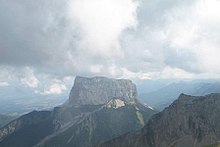
[4] The mountain is capped with meadows botanically similar to those on the Vercors High Plateau, but beneath the cliffs there are extensive forests.
[3] Geomorphologically, the mountain is a mesa-like outlier, that is to say, the remains of a plateau that has been otherwise eroded to leave only a single pillar of rock - weaker or fractured rocks (the so-called Jasneuf fault)[6] between the current summit and the Vercors high plateau were eroded over time by over 400 metres, leaving the peak standing on its own.
[6] Mont Aiguille is a limestone mesa, previously connected to the main body of the high plateau of the Vercors Massif.
[5] In the medieval period, Mont Aiguille was traditionally called "Mount Inaccessible", and typically depicted as an "inverted pyramid" or "mushroom".
[4] Charles VIII ordered that the peak be climbed, so one of his servants, Antoine de Ville, made the ascent using a combination of ladders, ropes and other artificial aids.