Montfode Castle
[8] Timothy Pont describes Montfode as "a pretty duelling beloninging to Heugh Monfodd of that ilk Laird therof.
[3] A wide selection of church related names are found on Armstrongs map of 1775, such as Kirklands, Kirkhill, Chapelaw and Crossmuir.
[14] Indications of artificial scarping are visible and aerial photography has revealed signs of two circular ditches nearby and one around the base of the mound.
Langhirst near Largs was held by John and later Hugh Montfode as a "5 merk land of old extent with commonage in the common of Lairges, 31st May, 1600".
[18] In 1467 King James III granted to Thomas Earl of Arran a large number of properties, including the 'Lands of Monfode'.
Montfode or Mountfud as the 1769 map records it,[3] was involved in the case of the murder of the 10th Earl of Eglinton by Mungo Campbell in 1769.
John Brown, tide-officer or tide-waiter at Saltcoats gave evidence that on the day of the Earl's death, Tuesday 17 October 1769, he was walking with Mungo Campbell and "They passed through the grounds of Montfodd, and thereafter crossed a burn, which is the march between the between Montfodd and the earl of Eglintoun's property, and went through lord Eglintoun's ground towards the sea.
[22] Mungo had permission from Dr. Hunter to shoot on the lands of Montfode, as well as preserve game and prosecute poachers.
[24] A Norman family, the name has many spellings, such as Monfode, Muntfod, Monfood, Monfodd, Monfoit, Monfoid, Montfoyd, etc.
They came to his house, assaulted his wife, striking her and pulling out much of her hair, taking the burgess to the tolbooth as a thief, imprisoning him for six hours, possibly at Montfode, and then putting him in the stocks.
[9] In 1526 James Montfode (probably brother to John[29]) was accused of taking part, together with the Earl of Eglinton and others, of murdering the Laird of Auchinharvie.
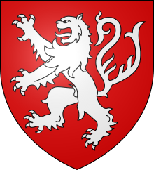
[16] It is suggested that the arms were the same as those of the Monfort family, namely; gules, a lion rampant queue fourchée argent.
It carries the figure of an 'armed man' and a carved shield bears a very worn image of an animal in rampant pose.
[32][39] James died in 1860 and the estate passed to his son John Carrick Moore of Corswell and Monfode who married Caroline Bradley.
She falls in love with Richard Hunter of Hunterston who returns from abroad a rich man; however, all of his wealth is lost in a shipwreck almost in sight of the shores of Scotland.
Emma, however, dies young and childless, her grave recorded as being an old grey slab, otherwise with illegible inscriptions but bearing the date 1661 and situated in the parish churchyard of Ardrossan.
[40] A battle axe was ploughed up in 1864 on top of Montfode Braes (name NS 224 439) near the remains of several ancient forts.
[44] A group of five buried storage tanks associated with the old Shell-Mex petrol refinery at Ardrossan were located just north of Montfode Castle.
[45] Five connected fish trap boulder alignments having a combined length of some 200 metres are located at the mouth of the Montfode Burn.
[46] John Brown and the exciseman, Mungo Campbell, were familiar with the foot of the Montfode Burn as being a "common haunt of smugglers" and the neck of marshy ground near Newhouse (now Burnhouse) as being a well known hiding place for smuggled goods.
[35] John Montfode, the last of that Ilk, was a commissioner of supply and also was appointed to the commission of inquiry into the state of the Scottish church in 1662.
[48] Dr John de Monfode is recorded in Robertson's index of charters as holding the lands of Braidwood in Lanarkshire.
The entrance lane at the old raised beach has an unusual planting in the hedgerow of several common whitebeam x wild service tree hybrids.