Montpelier, Vermont
[12] The city received a French name because the Franco-American alliance during the Revolutionary War had sparked widespread Francophilia.
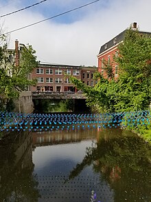
[14] The Winooski River flows by the south side of the city, passing by the state house and continuing northwest into Chittenden County.
[15] In 1875, fires destroyed 38 buildings in the city, and the commercial area was rebuilt with brick to avoid a repeat of the disaster.
[13] Historically, tradesmen shops and mills along the North Branch also fueled the economy, and sheds for finishing granite from Barre operated along the Winooski.
[12][16] Travelers can reach the city via the Amtrak Montpelier station, which is located 2 miles west of the downtown area and offers regular service on the Vermonter train.
[18] The level plain of nearly two hundred acres of the rich farmland, sheltered from winds by the surrounding valley made the area comparatively warm and comfortable.
[18] Native mounds, tombstones, and other memorials of aboriginal life and death were found in Montpelier, or in the vicinity, by the first settlers, and traces of some of them still remain.
[19] Originally chartered on August 14, 1781, the Town of Montpelier was granted municipal powers by the "Governor, Council and General Assembly of the Freemen of the State of Vermont".
Colonel Davis selected the name "Montpelier" after the French city of Montpellier, capital of the department of Hérault.
[20] There was a general enthusiasm for things French as a result of the country's aid to the American colonies during the Revolutionary War.
[11] The confluence of the Winooski, North Branch and Dog Rivers provided a central point for the local population and commerce.
[19] In 1825, the Marquis de Lafayette visited Montpelier on a triumphal tour of the United States, 50 years after the Revolutionary War.
In response to Montpelier's growth and changing demographics, on November 9, 1848, the General Assembly divided the original Town into two district municipal corporations.
[19] Ten thousand people turned out to greet Major General Philip Sheridan in 1867 when he visited to address the fourth annual meeting of Vermont former Union officers.
The prolonged heavy rains on top of the already saturated soil from the summer and fall proved to be more than the watercourses could handle.
[26] In response to the damage suffered by Montpelier and surrounding communities in the Great Flood of 1927, the Civilian Conservation Corps built the Wrightsville Dam during a period from 1933 to 1935.
The City of Montpelier grew slowly in the late 19th and early 20th centuries during the period of intensive out-migration from the state to new lands in the West, or to industrial centers elsewhere in New England.
[19] An early spring thaw in March 1992 caused an ice jam to form in the Winooski River downstream of the Bailey Avenue bridge in Montpelier.
In less than an hour, water levels in the Winooski and North Branch rivers rose upstream of the ice jam and flooded downtown Montpelier.
[14] The city center is a flat clay zone (elevation 520 ft; 160 m), surrounded by hills and granite ledges.
The Winooski River flows west along the south edge of downtown village and is fed by several smaller tributaries that cut through residential districts.
In winter, lows fall below 0 °F or −17.8 °C on 24 mornings and daytime highs stay below freezing for the majority of afternoons from December to February.
The Grand Depart of the Vermont Super 8 bikepacking route takes place on the steps of the capitol each fall.
Hubbard Park rises behind the state capitol building and extends along the ridge line towards the north past the pool to the stump dump.
Council members are elected on a nonpartisan ballot from three districts, with councilors serving staggered two-year terms.
These include local law enforcement, firefighting, planning and zoning regulation, and provision for potable drinking water and wastewater.
Both I-89 and U.S. 2 provide a direct link to Burlington and the populous Lake Champlain Valley in the northwestern corner of the state.
Amtrak, the national passenger rail system, provides daily service from its station at Montpelier Junction in the neighboring town of Berlin, on the route known as the "Vermonter", operating between St. Albans, Vermont and Washington, D.C. Greyhound and Megabus operate buses that serve Montpelier.
Air travelers in private planes can use the Edward F. Knapp State Airport in Berlin to access Montpelier.
The Burlington International Airport in Chittenden County is the closest commercial air service, located 35 miles (56 km) northwest of Montpelier.