Morris Canal
With a total elevation change of more than 900 feet (270 m), the canal was considered an ingenious technological marvel for its use of water-driven inclined planes, the first in the United States, to cross the northern New Jersey hills.
[a] It was built primarily to move coal to industrializing eastern cities that had stripped their environs of wood.
Like many enterprises that depended on anthracite, the canal's revenues dried up with the rise of oil fuels and truck transport.
A statewide greenway for cyclists and pedestrians is planned, beginning in Phillipsburg, traversing Warren, Sussex, Morris, Passaic, Essex, and Hudson Counties and including the old route through Jersey City.
[9] The canal was added to the National Register of Historic Places on October 1, 1974, for its significance in engineering, industry, and transportation.
The extension through Jersey City was at sea level and was supplied with water from the lower Hackensack River.
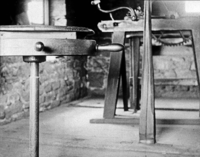
Surmounting the height difference was considered a major engineering feat of its day, accomplished through 23 locks and 23 inclined planes — essentially, short railways that carried canal boats in open cars uphill and downhill using water-powered winches.
On November 15, 1822, the New Jersey Legislature passed an act appointing three commissioners, one of whom was MacCulloch, to explore the feasibility of the project, determine the canal's possible route, and estimate its costs.
MacCulloch initially greatly underestimated the height difference between the Passaic and Lake Hopatcong, pegging it at only 185 ft (56 m).
The canal started from Upper Newark Bay, followed the Passaic River and crossed it at Little Falls, then went on to Boonton, Dover, then the southern tip of Lake Hopatcong, whereupon it went to Phillipsburg.
[14] Because the locks could only handle boats of 25 long tons (25 t), that meant that through traffic from the Lehigh Canal was impossible, requiring reloading coal at Easton.
[15] Lock dimensions were originally 9 feet (2.7 m) wide and 75 feet (23 m) long[18] Renwick's original design seems to have been to have double tracks on all inclined planes, with the descending caisson holding more water; thus, the system theoretically would not have needed external power.
In 1829, the canal company hired David Bates Douglass from West Point, who became the chief engineer of the planes.
[18] The Scotch turbines produced (for example, on Plane 2 West) 235 horsepower using a 45-foot (14 m) head of water and had a discharge rate of 1,000 cubic feet (28 m3) per minute.
[23] The Newark Eagle reported in 1830: The machinery was set in motion under the direction of Major Douglass, the enterprising Engineer.
The boat, with two hundred persons on board, rose majestically out of the water; in one minute it was upon the summit, which it passed apparently with all the ease that a ship would cross a wave of the sea.
As the forward wheels of the car commenced their descent, the boat seemed gently to bow to the spectators and the town below, then glided quickly down the wooden way.
This noble work, in a great degree, owes its existence to the patriotic and scientific energy of Mr. Cadwallader Colden.
[15] This initial section (not counting the Jersey City portion, which was done later) ran 98.62 miles (158.71 km) and cost $2,104,413 (equivalent to $64,226,685 in 2023).
[18] The original company failed in 1841 amid banking scandals, and the canal was leased to private bidders for three years.
First, the places where seepage occurred were lined with clay, and two feeders were dug, to Lake Hopatcong and to Pompton.
Traffic reached a peak in 1866, when the canal carried 889,220 long tons (903,490 t) of freight (equivalent to nearly 13,000 boatloads).
It also carried grain, wood, cider, vinegar, beer, whiskey, bricks, hay, hides, sugar, lumber, manure, lime,[35] and ice.
[36] Additional cargo include scrap metal, zinc, sand, clay, and farm products.
[32] In 1871, the canal was leased by the Lehigh Valley Railroad, which sought the valuable terminal properties at Phillipsburg and Jersey City.
The company won the suit in 1922, but the victory was Pyrrhic; the canal was now viewed as an impediment to the development of the area's water supply.
On the South Kearny, New Jersey, peninsula, where the canal ran just south of and parallel to the Lincoln Highway, now U.S. Route 1/9 Truck, the cross-highway bridges for Central Avenue and the rail spur immediately to its east were built to span the highway and the canal.