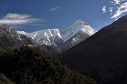
Mount Gongga
Mount Gongga (simplified Chinese: 贡嘎山; traditional Chinese: 貢嘎山; pinyin: Gònggá Shān), also known as Minya Konka (Khams Tibetan: མི་ཉག་གངས་དཀར་རི་བོ་, Khams Tibetan pinyin: Mi'nyâg Gong'ga Riwo) and colloquially as "The King of Sichuan Mountains", is the highest mountain in Sichuan province, China.
An early remote measurement of the mountain, then called Bokunka, was first performed by the Inner Asian expedition of the Hungarian count Béla Széchenyi between 1877 and 1880.
Forty-five years later, the mountain, this time called Gang ka, was sketched by China Inland Mission missionary James Huston Edgar from a distance.
[2] A richly illustrated large-format book about the expedition was eventually published by Imhof, Die Großen Kalten Berge von Szetchuan (Orell Fussli Verlag, Zurich, 1974).
A properly equipped American team composed of Terris Moore, Richard Burdsall, Arthur B. Emmons, and Jack T. Young returned to the mountain in 1932 and performed an accurate survey of the peak and its environs.
In May 1957 a Chinese mountaineering team claimed to have climbed Minya Konka via the Northwest Ridge route established by Moore and Burdsall.
The expedition, organized by Owens and sponsored by the American Alpine Club, attempted the still unclimbed and extremely technical west face of Minya Konka.
While the first ascent route up the Northwest Ridge appears technically straightforward, it is plagued by avalanches due to the mountain's highly unpredictable weather.
In October 2017, Chinese media reported that Pavel Kořínek, a Czech national, had reached the top of Gongga Shan, marking the first time since 2002 that the mountain had been successfully climbed.