Mount Keira
The suburb of Mount Keira, a semi-rural township of Wollongong, is located on the mountain's summit and southern flank.
The summit of Mount Keira has an elevation of 464 metres (1,522 ft) above sea level[3] that is located 4 kilometres (2.5 mi) northwest of the city of Wollongong.
[8] According to the Alcheringa, the dreaming of the local Aboriginal peoples, Mount Keira is Geera, the daughter of Oola-boola-woo, the West Wind.
They lived a-top the Illawarra escarpment, and one by one the first five children misbehaved, raising the ire of Oola-boola-woo, who cast them and the stone beneath them out to sea, forming the Five Islands.
[9] Mount Keira has been recognised as one of the most significant educational resources and teaching sites to the Dharawal people of the Illawarra region.
[11] These plans for further development have caused some contention in the Indigenous community, who want to ensure the site is respected as a place of spiritual and historical importance.
Mount Keira forms part of the Illawarra escarpment which it joins by a high saddle on the back (western) side.
[13] On the southern side, Mount Keira Road leaves suburbia and winds its way through the bush up the back of the mountain, giving access to the (now closed) Kemira coal mine, Byarong park, Girl Guides camp, Scout camp, and ultimately the summit lookout via Queen Elizabeth Drive.
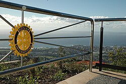
In 2005, the Summit Park refurbishment provided an opening up of magnificent vistas of the coastal plain from Kiama to Sydney, and is managed as an annexe of the Wollongong Botanic Garden.
[16] On a good day it is easy to see the northern escarpment and, from the Victoria Rock Lookout, reached by a short trail or cliff track, one can see Knights Hill, Mount Kembla and Saddleback Mountain clearly.
Summit facilities include car parking spaces, toilets, picnic areas with wooden tables and benches and a kiosk/restaurant, the Mountaintop.
In 2006 binocular telescopes were fitted, and after several tests, vandalism and malfunctioning being a problem, they are currently in use for gold coin donation to the rotary club.
The summit lookout and Queen Elizabeth Drive was officially opened in 1959, but attempts to secure land from Australian Iron & Steel began in 1954.
Both a map and plaque remain from the original lookout park design, though the previous hang-gliding ramp has been taken down for the new observation walkways.
Red cedar, in particular, was highly prized and there are stories of giant trees with trunk diameters of 3 metres (9.8 ft) or more being felled.
The walk can be commenced from a number of locations, including Mount Keira summit, Byarong Park, the Scout Camp and Queen Elizabeth Drive.
The right branch traverses the mountain's eastern flank, before emerging at Geordies Flat on Mount Keira Road.
From Geordies Flat, the northern branch of the Ring Track climbs steadily to the junction of Mount Keira Road and Queen Elizabeth Drive.
At this point, walkers can also join the Robertsons Lookout track, a short 1.2-kilometre (0.75 mi) walk that terminates at a viewpoint that takes in the Scout Camp, Mount Keira and the Illawarra coast.
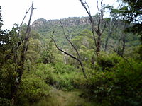
Highlights of the Ring Track are rainforest and many species of unique Australian animals, including wallabies, lyrebirds, brush turkeys, echidnas.
From Mount Keira summit, fine views of Warra to the south and Brokers Nose Promontory to the north can be seen.
A similar feature, an early attempt to construct a carriageway, is visible west of the summit track on Mount Kembla.
The Dave Walsh Track, named after a Scout leader, climbs from Mount Keira Road opposite the Scout Camp road through a small open area of ground ferns, up the western slope of Mount Keira, to Five Islands Lookout and the Summit Track.
The sculpture was made from 1988 to 1989 by Herbert "Bert" Flugelman, and is of stainless steel and part of the University of Wollongong Art Collection.
After this the track goes along gradually climbing a ridge until it reaches the Northern Illawarra Lookout, which gives views to the north and has a plaque telling of the shipwreck at Towradgi Point.
The track goes up some more wooden steps and reaches a brick airshaft completed in 1907 used to ventilate the Kemira Colliery, and a plaque tells of the mine's history.
The track is popular with joggers and tourists, and has many plaques indicating various sights such as a remaining grey ironbark left from extensive logging in the late 19th century and several plants such as the invasive weed Lantana Camara and the native Settlers Flax.
Large boulders are evidence of previous rockfalls from the sandstone plateau, which forms the escarpment cliffs and Mount Keira summit.
The track forms a short 600-metre (2,000 ft) loop when combined with a management trail that leads between the Five Islands lookout and the summit car park.
[18] On 16 April 1857 the first 3.5 long tons (3.6 t) of coal from the new mine was delivered to the wharf at Wollongong's Belmore Basin by bullock team for trial in the S.S. Illawarra.