Mount Kenya
Many alpine species are endemic to Mount Kenya, such as the giant lobelias and senecios and a local subspecies of rock hyrax.
[13] An area of 715 km2 (276 sq mi) around the centre of the mountain was designated a National Park and listed as a UNESCO World Heritage Site in 1997.
[20] The Maasai name for Mount Kenya is Ol Donyo Keri, which means 'mountain of stripes', referring to the dark shades as observed from the surrounding plains.
[26] At least one Maasai prayer refers to Mount Kenya: God bless our children, let them be like the olive tree of Morintat, let them grow and expand, let them be like Ngong Hills like Mt.
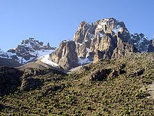
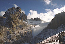
[3] After studying the moraines, Gregory put forward the theory that at one time the whole summit of the mountain was covered with an ice cap, and it was this that eroded the peaks to how they are today.
The rivers in the northern part of the mountain, such as the Burguret, Naru Moru, Nanyuki, Likii, and Sirimon flow into the Ewaso Nyiro.
Various species of monkeys, several antelopes, tree hyrax, porcupines, and some larger animals such as elephants and buffalo all live in the forest.
Some smaller mammals, such as the groove-toothed rat, can live here by burrowing into the giant senecios and using their thick stem of dead leaves as insulation.
[34] Several bird species live in the Afro-alpine zone, including sunbirds, alpine chats and starlings and the raptors, augur buzzard, lammergeier and Verreaux's eagle, the latter of which specializes in hunting hyraxes.
[48] The climate of Mount Kenya has played a critical role in the development of the mountain, influencing the topography and ecology amongst other factors.
[55] As Mount Kenya ranges in height from 1,374 to 5,199 m (4,508 to 17,057 ft), the climate varies considerably over the mountain and has different zones of influence.
Large daily temperature fluctuations occur which led Hedberg to exclaim winter every night and summer every day.
Low on the mountain, between 2,400 and 3,900 m (7,874 and 12,795 ft), clouds begin to form over the western forest zone, due to moist air from Lake Victoria.
[40] The anabatic winds caused by warm rising air gradually bring these clouds to the summit region in the afternoon.
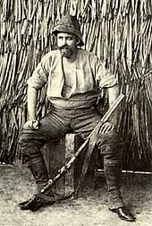
[57] The first European to report seeing Mount Kenya was Dr Johann Ludwig Krapf, a German missionary, from Kitui,[60] a town 150 km (90 mi)[5] away from the mountain.
This expedition was traveling from the coast to Lake Baringo in the Rift Valley and was led by Dr. John W Gregory, a British geologist.
[34] George Kolb, a German physician, made expeditions in 1894 and 1896[34] and was the first to reach the moorlands on the east side of the mountain.
[34][64] On 28 July 1899,[64] Sir Halford John Mackinder set out from the site of Nairobi on an expedition to Mount Kenya.
When they reached the base camp on 18 August,[64] they could not find any food, suffered two of their party killed by the local people, and eventually had to send Saunders to Naivasha to get help from Captain Gorges, the Government Officer there.
A Church of Scotland mission was set up in Chogoria, and several Scottish missionaries ascended to the peaks, including Rev Dr. J. W. Arthur, G. Dennis and A. R. Barlow.
[69] In the early 1970s the Mount Kenya National Park Mountain Rescue Team was formed, and by the end of the 1970s, all major routes on the peaks had been climbed.
[66] On 19 July 2003, a South African registered aircraft, carrying 12 passengers and two crew, crashed into Mount Kenya at Point Lenana; nobody survived.
[72] In March 2012 a massive fire raged on Mount Kenya, devouring thousands of hectares of ancient forests and endangered wildlife.
The first recorded ascent of Batian was on 13 September 1899 by Sir Halford John Mackinder, Cesar Ollier, and Josef Brocherel.
Snow and ice levels on the mountain have been retreating at an accelerated rate in recent years, making these climbs increasingly difficult and dangerous.
Starting clockwise from the north these are the: Meru, Chogoria, Kamweti, Naro Moru, Burguret, Sirimon, and Timau Routes.
It heads through the forest to the south-east of the mountain to the moorland, with views over areas such as Ithanguni and the Giant's Billiards Table before following the Gorges Valley past the Temple and up to Simba Col below Point Lenana.
The route starts at Naro Moru town to the west of the mountain and climbs towards Mackinder's Camp before joining the Peak Circuit Path.
[citation needed] The origin of the name Kenya is not clear but perhaps linked to the Kikuyu, Embu, and Kamba words Kirinyaga, Kirenyaa and Kiinyaa which mean "God's resting place" in all three languages.
In the 19th Century, the German explorer, Ludwig Krapf, recorded the name as both Kenia and Kegnia believed by some to be a corruption of the Kamba version.