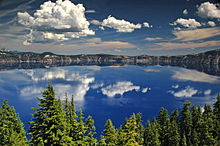
Mount Mazama
Mount Mazama formed as a group of overlapping volcanic edifices such as shield volcanoes and small composite cones, becoming active intermittently until its climactic eruption 7,700 years ago.
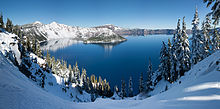
Recreational activities including hiking, biking, snowshoeing, fishing, as well as cross-country skiing are available; during the summer, campgrounds and lodges at Crater Lake are open to visitors.
It receives about 500,000 visitors each year, and these tourists can go hiking, take bike, ranger-guided, and trolley tours, swim, fish, camp, and participate in other recreational activities.
[14] When the climactic eruption occurred, the climate was warm and dry,[15] and the most recent period of glacial advance ceased about 27,000 years ago, so by the time Mazama collapsed, ice was likely only present at higher elevations.
Hawaiian eruptions from neighboring shield volcanoes also built up Mazama, producing basaltic andesite lava flows that ranged from 15 to 20 feet (4.6 to 6.1 m) on average in thickness.
Outside of the caldera, most hills show evidence of glacial alteration except those from the Holocene epoch and low elevation landforms including Pleistocene lava domes and cinder cones.
[41] About 70,000 years ago, several silicic (rich in silicon dioxide), explosive eruptions occurred, including a significant event at Pumice Castle on the eastern wall of Mazama.
During this period of the late Pleistocene or early Holocene,[41] lava domes such as those at Sharp Peak, Grouse Hill, and Merriam Point formed,[1] sharing chemical compositions, with silica contents at about 70%.
At about 420,000 years old, Mount Scott has a conical shape, but has been extensively altered by Pleistocene glacial erosion, which carved a large cirque on its western flank and smaller ones on its eastern and northeastern sides.
[45] About 75,000 years ago, the volcano erupted effusive lava flows of andesite that formed 980-foot (300 m) thick deposits below Hillman Peak that extended at least 4.3 miles (7 km) from the caldera rim.
Between 30,000 and 25,000 years ago, rhyodacitic eruptions occurred at the complex, yielding pumiceous tephra and lava flows from Grouse Hill, Steel Bay, and Redcloud Cliff.
At Redcloud Cliff, a lava flow formed with glassy columns that touched glaciers, creating a large, inverted stone triangle on the eastern rim of Mazama.
Eventually, the top of Mazama's magma chamber subsided, and concentric openings formed by the summit, producing smaller vents surrounding the main eruptive cone.
Pumice ejected from these new fractures created rapid pyroclastic flows that coursed down all the sides of Mazama, traveling over tall ridges and summits of subfeatures and extending tens of miles from their vents.
[61] Some of the flows traveled more than 40 miles (64 km) from their source, destroying timber in their paths, while others deposited their rock into river valleys to the north and west of Mazama, leaving layers of pumice between 20 and 30 feet (6.1 and 9.1 m) in thickness.
[75] In the western United States and Canada, volcanic ash often forms distinct layers among recent geological deposits, which can be used for stratigraphy among geologists and archaeologists.
The ejection of lava rich in gas from shallow water could produce huge ash columns, but submarine eruptions at deeper depths may decrease the explosiveness of the event.
[22] Earthquakes from the nearby West Klamath Lake fault zone could reach magnitudes up to 7.0 on the Richter scale, but these only occur every 3,000 to 10,000 years; they could generate tall waves by creating landslides.
[91] Minor hydrothermal explosions could still potentially be dangerous, as the ejection of ballistic blocks or tall waves could threaten people standing near the lake,[92] traveling at speeds from 330 to 820 feet per second (100 to 250 m/s).
[94] Studies of heat flow and the water chemistry in Crater Lake and the alteration of rocks older than 120,000 years ago suggest that hydrothermal areas exist in the Mazama vicinity.
[98] Ecological disturbances tend to cause decreasing damage with increasing distance from the source, but volcanic eruptions can lead to more uniform patterns of disruption for their surrounding landscapes.
The mammals of the National Park area also include various species of squirrel, mice, vole, and gophers, as well as yellow-bellied marmots and North American porcupines.
Common bird species include hairy woodpeckers, great horned owls, blue grouse, common ravens, dark-eyed juncos, mountain chickadees, red-breasted nuthatches, brown creepers, Clark's nutcrackers, and Canada jays, which are visible throughout the year; American kestrels, northern flickers, golden-crowned kinglets, Cordilleran flycatchers, Steller's jays, western tanagers, Swainson's thrushes, hermit thrushes, American robins, and rufous hummingbirds that frequent the area in the summer season; and mountain and western bluebirds in the fall and summer.
By 1992, Crater Lake National Park initiated a bull trout conservation project, removing invasive fish populations with electrofishing, snorkeling, and introduction of the toxin and inhibitor of cellular respiration antimycin A.
[102] Climate change threatens the American pika populations in the Crater Lake area, as they cannot tolerate warm weather because their fur does not release heat efficiently.
[103] During the 19th century, one Klamath leader named Lalek predicted scientific discoveries that described Mount Mazama's destruction, claiming that it had collapsed as a result of a particularly violent eruption.
Geologists had not discovered this mechanism for caldera formation yet, but the hypothesis was recorded by the soldier William M. Colvig in 1865, and then reprinted in Ella Clark's Indian Legends of the Pacific Northwest.
[17] Eleven miners from Yreka, California, stopped at a mercantile store in Jacksonville, Oregon, owned by Isaac Skeeters, boasting that they knew where to find a gold mine called "Lost Cabin."
The conservation movement in the United States was gaining traction, so Steel's efforts to preserve the Mazama area were achieved on two scales, first with the creation of the local Cascade Range Forest Reserve in 1893, and then on May 22, 1902, with the recognition of Crater Lake National Park.
[108] After conducting research at Mazama during the 1880s, in 1902, Joseph S. Diller published a major report with the United States Geological Survey concerning Crater Lake National Park.