Orjen
Orjen (Serbian Cyrillic: Орјен, pronounced [ɔ̂rjɛn]) is a transboundary Dinaric Mediterranean limestone mountain range, located between southernmost Bosnia and Herzegovina and southwestern Montenegro.
The massif of Orjen lies east to south-east of Trebinje in Bosnia and Herzegovina and north-west of Risan in Bay of Kotor (Boka Kotorska).
From the town of Risan, situated at the innermost protected part of the bay, a well-engineered road, at first metalled, with many hairpin bends climbs to about 1600 m, over to the interior.
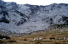
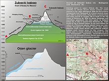
At the main summit of Orjen and the surrounding ridges and high plateaus the action of quaternary glaciation is evident.
During the Ice Age, long valley glaciers receded from Orjen to the Bay of Kotor and surrounding poljes.
Snow patches collected from deep pit holes were used even late in the 20th century to provide the few hamlets with water.
With 1895 m difference between the lowest and the highest point, relief energy has a great role in the extremely harsh environment.
A hyperkarstic barren landscape of vast karren fields contrasts with very species rich vegetation types, ranging from evergreen deciduous forests at lower altitudes to endemic calcareous Dinaric Fir and Pine forests in higher altitudes.
The ridges are arranged by elevation with the highest to the north screening the Bijela gora plateaux from the Mediterranean coast.
The poljes of Grahovo, Dragalj, Vrbanj, Krusevica and Grabalj are important for agricultural use and provide the only lines of communication in the karst.
Migration circled around Mount Orjen as a major obstacle between the coastal, Herceg Novi and Risan and the interior towns of Grahovo, Trebinje and Nikšić.
Mediterranean mountains bear no glaciers any more except small snow fields in some shaded cirques of the Taurus range.
Glaciers were only of local significance in the Mediterranean enabling frost sensitive vegetation types to survive the climate changes of the Quaternary.
All part above 900 m were buried under a thick sheet of ice from where several glacial tongues descended to 500 m above sea level.
Many cirques, U-shaped valleys and moraines and jagged ridges and summits bear the evidence of the glacial erosion.
A major disadvantage is that the water is percolating fast in the porous rocks and does not form brooks and rivers despite the heavy amounts of precipitation.
During the time of the Ottoman rule from the 15th to the 19th century the high karst was acting as main shelter for the Christian population.
Military campaigns of Ottomans and Austro-Hungarians faced heavy losses while both great powers underestimated the difficulties to undertake successful raids in karst areas.
Mount Orjen is completely built of folded Cretaceous limestones which belongs to the High-Karst Zone geological unit.
The terrain of this geotectonic unit is mainly built up of Mesozoic (Triassic, Jurassic and Cretaceous) limestones and dolomites of several kilometres of thickness.
The vast differences in water-yielding capacity of the constant and periodic karst springs point out to the strong karstification of High-Karst Zone limestones and dolomites on Mount Orjen.
Like the monsoon rain is seasonally distributed, thus November thunderstorms sometimes pour 2000 L of water in several days, while August is frequently completely dry leading to forest fires.
Strong cold downslope winds of Bora type appear in winter and are most severe in the Bay of Risan.
Gusts reach 250 km/h and can lead to a significant fall of temperatures in several hours with freezing events problematic for most of the Mediterranean cultures.
* monthly and yearly precipitation ranges in Dalmatia, Herzegovina and Montenegro Mostly limestone rocks but also moraines and screes.
Dinaric calcareous fir forests are found in several grooves on the Bijela gora but are difficult to reach.
The typical karst country with bare limestone rochocks interspersed with parches of wood is found on lower altitudes.
White Oak, Hop-hornbeam and Montpellier Maple, or the characteristic scrub of the maquis shrubland and garrigue are notable.
They have their local songs describing life on the remote mountain and every year in July a great feast takes place when all the shepherds from Bijela gora come together to sing dance and eat on a pasture at Ledenik.
Marked trails start at the city bus station at Herceg Novi (30 m) and lead to the Vratlo hut (1160 m).