Mount Price (British Columbia)
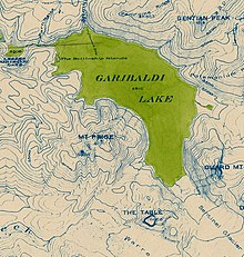
It has an elevation of 2,049 metres (6,722 feet) and rises above the surrounding landscape on the western side of Garibaldi Lake in New Westminster Land District.
The mountain contains a number of subfeatures, including Clinker Peak on its western flank, which was the source of two thick lava flows between 15,000 and 8,000 years ago that ponded against glacial ice.
This ecosection is characterized by a rugged landscape of mountains that increase in elevation from south to north; the northern summits contain large icefields.
[7] Wildlife such as grey jays, chipmunks, squirrels, flickers, deer, mountain goats, wolverines, cougars and grizzly and black bears are locally present.
[8] The communities of Whistler, Pemberton, Mount Currie, Hope and Yale are situated within the Eastern Pacific Ranges Ecosection, all of which are connected to the Lower Mainland by a network of highways.
This consists of several volcanoes and lava flows that formed in the last 1.3 million years; the oldest volcanic rocks are found at Mount Price and The Black Tusk.
[a][1][3] Although no hot springs are known in the Garibaldi area, there is evidence of anomalously high heat flow in Table Meadows just south of Mount Price and elsewhere.
[3] The first eruptive phase 1.2 million years ago deposited hornblende[c] andesite lava and pyroclastic rocks on the floor of the cirque-like basin after an Early Pleistocene[d] glacial event.
[3][16] During the Middle Pleistocene[e] about 300,000 years ago, volcanism of the second phase shifted westward and constructed the nearly symmetrical stratovolcano of Mount Price.
Later, the volcano was overridden by the Cordilleran Ice Sheet, which covered a large portion of western North America during glacial periods of the Quaternary.
[3][5][16] These eruptions resulted in the creation of a small lava dome or scoria cone on Mount Price's northern flank with an elevation of 1,788 m (5,866 ft).
[3][16] Their unusually large thickness is due to them ponding and cooling against the Cordilleran Ice Sheet when it still filled valleys at lower elevations.
An eruption producing floods and lahars could destroy parts of Highway 99, threaten communities such as Brackendale and endanger water supplies from Pitt Lake.
[19] Mount Price is also close to a major air traffic route; volcanic ash reduces visibility and can cause jet engine failure, as well as damage to other aircraft systems.
[19] Concerns about The Barrier's instability due to volcanic, tectonic or heavy rainfall activity prompted the provincial government to declare the area immediately below it unsafe for human habitation in 1980.
[20] This led to the evacuation of the small resort village of Garibaldi nearby and the relocation of residents to new recreational subdivisions away from the hazard zone.
Although landslides are unlikely to happen in the near future, warning signs are posted at the zone to make visitors aware of the potential danger and to minimize the chance of fatalities in the event of a slide.
For safety reasons, BC Parks recommends visitors not to camp, stop or linger in the Barrier Civil Defence Zone.
[8] Like other volcanoes in the Garibaldi Lake volcanic field, Mount Price is not monitored closely enough by the Geological Survey of Canada to ascertain its activity level.
The Canadian National Seismograph Network has been established to monitor earthquakes throughout Canada, but it is too far away to provide an accurate indication of activity under the mountain.
Located 70 km (43 mi) north of Vancouver in the glaciated Coast Mountains, Garibaldi Provincial Park contains diverse vegetation, iridescent waters and a rich geological history.
[2][28] In 1952, Canadian volcanologist William Henry Mathews identified Mount Price as Clinker Mountain in the American Journal of Science.
[30] Daisy Lake Road, 30 km (19 mi) north of Squamish, provides access to Garibaldi Provincial Park from Highway 99.
[4][38][37] This poorly marked path ascends to the shore of Garibaldi Lake and then returns inland where it traverses south along the lava flow forming The Barrier.