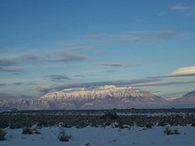
Mount Timpanogos
[3] The mountain towers about 7,000 ft (2,100 m) over Utah Valley, including the cities of Lehi, Provo, Orem, Pleasant Grove, American Fork, Lindon and others.
Ice Age glaciers mantled the peak until relatively recently and dramatically shaped the mountain into an Alpine tableau of knife-edge ridges and yawning, U-shaped amphitheaters.
Timpanogos Glacier is a rock-covered mass found on a long, north-facing slope and usually has patches of snow the entire year.
The locally unique ice is a relic of the region's formerly colder climate and has long been a major attraction to hikers and climbers on the mountain, who often slide down its permanent snowfield as a shorter descent route.
Although it is a 14-mile (23 km) round-trip hike, with almost 5,300 feet (1,600 m) of elevation gain, Timpangos's summit is one of the most frequently visited in the Rocky Mountains.
It also created the need for infrastructure, such as the stone shelter built in 1959 near Emerald Lake and a smaller metal shack on the summit (this was used as an observation deck complete with brass rods etched with notches aligned with various landmarks).
The limestone was subsequently lifted high above sea level and the mountain itself became prominent as the Western valley sank due to basin and range faulting.
Since 1982 the Timpanogos Emergency Response Team ("TERT") has been established on the mountain on weekends to provide first aid, rescue and communication.
In the early 1900s Eugene Lusk "Timp" Roberts, a professor at Brigham Young University, initiated an annual hike and pageant intended to "sell Timpanogos to the world.
Roberts wrote his folk tale of the maiden Utahna and her sacrifice to her gods with this as the launch point, with one version the basis for a ballet.