Kura (South Caucasus river)
Starting in northeastern Turkey, the Kura flows through to Georgia, then into Azerbaijan, where it receives the Aras as a right tributary, and finally enters the Caspian Sea.
Large, complex civilizations eventually grew on the river, but by 1200 CE most were reduced to ruin by natural disasters and foreign invaders.
The increasing human use, and eventual damage, of the watershed's forests and grasslands, contributed to a rising intensity of floods through the 20th century.
Previously navigable up to Tbilisi in Georgia, the Kura is now much slower and shallower, having been harnessed by irrigation projects and hydroelectric power stations.
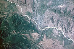
It arcs to the northwest, then into a canyon near Akhaltsikhe where it starts to run northeast in a gorge for about 75 kilometres (47 mi), spilling out of the mountains near Khashuri.
[14] The Kura then empties into Mingachevir reservoir, the largest body of water in Azerbaijan, formed by a dam near its namesake town at the southeastern end.
After leaving the dam, the river meanders southeast where it meets its biggest tributary Tartarchay in Barda Rayon and continues across a broad irrigated plain for several hundred kilometers, turning east near Lake Sarysu, and shortly after, receives the Aras, the largest tributary, at the city of Sabirabad.
At the Aras confluence it makes a large arc to the north and then flows almost due south for about 60 kilometres (37 mi), passing the west side of Shirvan National Park, before turning east and emptying into the Caspian Sea at Neftçala.
The lower part of the river flows through the Kura-Aras Lowland, which covers most of central Azerbaijan and abuts the Caspian Sea.
The course change is believed to be the result of a rise in the level of the Caspian Sea coupled with a major flood of the Kura.
[17] Because of high water use, many of the smaller tributaries of the Kura no longer reach the river, instead disappearing in the plain many kilometers from their original mouths.
Forest cover is sparse, especially in the Kura and Aras headwaters, and most of the water that falls on the highlands becomes runoff instead of supplying groundwater.
Leaking water causes groundwater to rise, in some areas so high that about 267,000 hectares (660,000 acres) of land are so waterlogged that they are no longer suitable for agriculture.
[23] But perhaps the most famous of the ancient settlements on the Kura is the "cave town" at Uplistsikhe, Georgia, first settled as early as 3,500 years ago.
The city, carved into a cliff on the bank of the Kura covering an area of 8 hectares (20 acres), contains underground living quarters, communal chambers, places of worship, storerooms, connected by a network of passageways.
It reached its peak about 1,100 years ago as the political, religious and cultural center of the region, but in the 13th century, it fell to Mongolian invaders.
[25] Even though irrigation agriculture had been well established for thousands of years, until the 1920s, humans did not have a significant effect on the ecology or hydrology of the Kura catchment area.
[26] In the 1950s and 1960s, when the Caucasus region was part of the Soviet Union, construction of many of the reservoirs and waterworks in the Kura basin began.