Muncaster Fell
The fell forms a long, low, yet steep-sided ridge that separates the southern portions of the valleys of Miterdale and Eskdale.
Along the southern end of the fell ridge runs a straight track, climbing up past the tarn toward Hooker Crag.
There is a small, low dolmen, which despite its stone age appearance is inscribed Ross's Camp 1883 on the top surface (GR: SD121987) and was apparently built by a shooting party of that date as a luncheon table.
Being relatively isolated and situated on the coast, views from the fell top include both the mountains of central Cumbria to the northeast, and the coastal plain to the northwest and south.
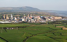
However, these landmarks were dismantled in the early years of the new millennium, and with the gradual removal of other chimneys and cooling towers associated with the power station, the Sellafield site is now far less imposing.
Modern electricity generation technology is very evident, however, as the white turbines of the Walney Wind Farms are clearly visible in the Irish Sea to the southwest.
The lowest slopes are generally covered in glacial diamicton derived from the igneous lithologies nearer the centre of the Lake District, and the steeper crags give rise to localised scree deposits.