NORAD Tracks Santa
On December 24, 1948, the United States Air Force issued a communique claiming that an "early warning radar net to the north" had detected "one unidentified sleigh, powered by eight reindeer, at 14,000 feet [4,300 meters], heading 180 degrees.
It was the first time that the United States Armed Forces issued a statement about tracking Santa Claus' sleigh on Christmas Eve, though it was a one-time event, not repeated over the next several years.
[11][12] Some sources claim that he received numerous similar calls that night, in response to which he had his operators give children the "current location" for Santa Claus.
In his release to the press, Oldfield added that "CONAD, Army, Navy, and Marine Air Forces will continue to track and guard Santa and his sleigh on his trip to and from the U.S. against possible attack from those who do not believe in Christmas.
On December 24, 1960, for example, NORAD's northern command post at Saint-Hubert, Quebec, Canada, provided regular updates of a supposed sleigh operated by "S. Claus" which it identified as "undoubtedly friendly".
During the evening, NORAD claimed that the sleigh had made an emergency landing on the ice of Hudson Bay, where Royal Canadian Air Force (RCAF) interceptor aircraft claimed to have been sent to investigate supposedly discovered Santa bandaging his reindeer Dancer's front foot, after which the RCAF planes were said to have escorted him when he resumed his journey.
[9] Eventually, NORAD, which was renamed the North American Aerospace Defense Command in 1981, openly published a hotline number for the general public to call to get updates on Santa Claus' supposed progress.
[15] Not only does NORAD simulate the tracking of Santa's sleigh, but it also tells the user the exact amount of presents he is "delivering" at any moment on Christmas Eve.
NORAD begins "tracking" at midnight MST, and even provides a depiction of Santa's pre-delivery ritual.
[22] They would operate with a limited number of volunteers answering calls and some people who try to reach the Santa-tracking hotline would receive an automated message.
Many television newscasts in North America feature NORAD Tracks Santa as part of their weather updates on Christmas Eve.
[27] In 2011, an iOS and Android application was introduced, which features updates and an interactive game similar to the Christmas levels in Angry Birds Seasons, called Elf Toss.
On Christmas Eve, the NORAD Tracks Santa website videos page is generally updated each hour, when it is midnight in a different time zone.
Each video was accompanied by a voice-over until the end of the 2011 season, typically done by NORAD personnel, giving a few facts about the city or country depicted.
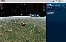
[32] Since 2012, Analytical Graphics, Inc. has used their Cesium platform to build a 3D map for visualizing Santa's location with more accurate global terrain and satellite imagery than before.
Naval Reserve Navy Information Bureau (NIB) 1118 at Fort Carson, Colorado,[38][39] as have the Canadian Armed Forces.