Nandewar Range
The range is situated approximately 30 km (19 mi) east of the township of Narrabri.
John Oxley was the first European to see the range in 1818 as he explored the New South Wales.
[1] The range is located on the western, inland, side of the New England region, and generally forms the watershed divide between the Namoi River and Gwydir River catchment basins to the south and north respectively.
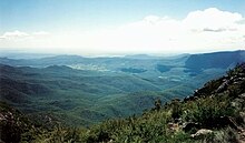
At its western end, the Nandewar Range culminates at Mount Kaputar, a complex of volcanic origin, from which there are views of the flat inland plains of New South Wales.
[2] The range is the remnants of an eroded basaltic shield volcano that formed about 18 million years ago.