National Blue Trail
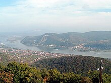
All segments of the trail are freely accessible to the public; no fees have to be paid or permits obtained, there is only one ferry to take over the Danube between Visegrád and Nagymaros where you have to purchase a ticket.
During its course the Blue Trail visits arguably the most beautiful natural and man-made sights of Hungary, e.g. more than a dozen forts and castles, lookout towers, three World Heritage Sites of Hungary (the panorama of Budapest from the hills, the old village of Hollókő and the Stalactite Cave of Aggtelek), Lake Balaton, the Danube Bend, and the spent volcanoes of the Basin of Tapolca, etc.
A lot of Hungarian hikers began the completion of the Trail after World War II, so the Nature Rambler Section of the Lokomotív Sport Club of Budapest announced the National walk on the "blue" hiking path in 1952.
The Nature Rambler Section's Committee of Railway Employee's Union developed this issue on the national level in 1953, and published the first brochure, which showed the whole route in map sketches.
Later, organisation and control of the National Blue Trail movement was taken over by the Hungarian Rambler's Association "Friends of Nature" (MTSZ) in 1961.
The organiser and editor of this series was Pál Rockenbauer, who at that time worked in the editorial office named "Natura" of the Hungarian TV.
Pál Rockenbauer organised a small team and they completed the National Blue Trail during 76 days in an east-west direction.
Pál Rockenbauer committed suicide in 1987 during a hike on the paths of the Blue Trail close to village Katalinpuszta at the foot of the Naszály Mountain.
The 870 kilometers long trail runs between the RPDDK endpoint Szekszárd and Sátoraljaújhely, almost reaching the eastern end of OKT crossing the mostly flat Great Hungarian Plain region.
Popularity continued to grow throughout the decade as the route was given a complete facelift with new signposts and waymarkers, on many sections it was rerouted for more convenient use.
Due to marketing success and renewed interest in hiking (which was further catalyzed by the Covid-19 pandemic), the number of completions reached 500 for 2021 and 800 for 2022, making them the most popular years in the history of the Blue Trail.
After completing the entire trail, the booklet must be sent to the Hungarian Ramblers’ Association (MTSZ) in Budapest for verification, after which the official certificate and commemorative badge are issued.
The badge is an irregular quadrangle with a road leading towards mountains with a blue signed post and below in red stripe with the following: "Országos Kék-túra MTSZ".
Stamping places: Lookout Tower of Írottkő, Hétvezér-forrás (Spring of Seven Leaders), Kőszeg, Tömörd, Ablánci Malomcsárda (Water Mill Tavern of Ablánc), Szeleste, Bögöt, Csényeújmajor, Sárvár railway station, Gérce, forester's lodge of Rózsáskert, hunter's lodge of Hidegkút, village Káld, village Hosszúpereszteg, forester's lodge of Szajk at Lakes of Szajk, Ötvös railway station, Kisvásárhely, Sümeg railway station 129.9 km, 2870 metres climb At the town of Sümeg the Blue Trail reaches the edge of the plain and the route goes on among the 200–300 metres tall hills of the Balaton Highlands.
Stamping places: Nagyvázsony, forester's lodge of Kab-hegy, Úrkút, Városlőd-Kislőd railway station, Németbánya, Bakonybél, peak of Kőris Mountain, Borzavár, Zirc railway station, Bakonynána, Jásd, Tés, Kisgyón, Bakonykúti, Fehérvárcsurgó, Bodajk 115.7 km, 3110 metres climb The route of the Blue Trail goes through the forest of the about 400 meters high volcanic plateau of the Vértes and reaches the Gerecse Hills.
Stamping places: Bodajk, Csókakő, Gánt, Mindszentpuszta homestead, Kőhányáspuszta, Castle of Gesztes, Szárliget railway station, tourist shelter of Somlyóvár, hunter's lodge of Koldusszállás, ruins of the forester's lodge of Bányahegy, children's holiday resort on the Gerecse Mountain, Pusztamarót homestead, pilgrimage place Péliföldszentkereszt, Mogyorósbánya, Tokod, Dorog railway station.
Stamping places: Mátraverebély, Tourist Hostel of Ágasvár, Mátraszentistván, the peak of Galyatető, forester's lodge of Nyírjes, Vörösmarty Tourist Hostel, Mátraháza, the peak of Kékestető, forester's lodge of Hármashatár, Sirok railway station, Restaurant Hunor in Sirok, forester's lodge of Rozsnakpuszta, Szarvaskő 116.6 km, 3150 metres climb The path climbs the 800–900 metres high plateau of the Bükk Mountains, then it descends into the valley of Sajó River.
Stamping places: Szarvaskő, Telekessy Guesthouse, Bélapátfalva, Cserepes-kő Cave Shelter, Bánkút Ski House, Mályinka, Uppony, Putnok railway station, Kelemér, Gömörszőlős, Zádorfalva, Aggtelek, Jósvafő, ruins of Derenk, ruins of Szabó-pallag forester's lodge, Bódvaszilas railway station.
After crossing the hills from west to east, the path takes a sharp northwesterly turn near Sátoraljaújhely and finally climbs the highest peak of the mountains: the Nagy-Milic (895 m) which stands on the Hungarian-Slovakian border.