Natural Steps, Arkansas
The small town was named after "two perfectly parallel vertical walls of sandstone, twenty feet apart, [that] jut out from the disintegrated soft slates, in prominent conformity, descending steplike, fifty-one feet from the top of the bank, where they first show themselves, to the edge of the lowest water-mark of the Arkansas River, and can be seen running their course beneath the stream.
[7] Beginning in 1822, the local "Natural Steps" provided a convenient stop for Little Rock visitors to disembark for their hike to the mountain."
Seen from the River at a little distance, they have a wonderfully artificial appearance, looking like steps laid by regular masonry, and form, indeed, not only a remarkable feature in the landscape, but also a striking and unequivocal instance, of which Arkansas furnishes several, of strata tilted nearly on edge.
wrote, "The first inhabitants of the Natural Steps area were Native Americans, Indians whose presence in the vicinity dates back possibly 10,000 years."
During early European explorations and the colonial period, local Native Americans, from about 1500 to the late 1700s, were the Quapaw, which translates to "down stream people."
The Pinnacle Mountain Community Post wrote: History reveals the French were notorious traders with the Natives and perhaps many canoe or river raft pulled up and tied off in the area.
The boat left Little Rock promptly at 8:30 a.m. and after traversing our beautiful river, with its varied and picturesque scenery for about thirty miles duly reached its point of destination, the Natural Steps, where the excursionists disembarked and sought the shady groves in the vicinity, where they indulged in picnicking in the true and time-honored style; after when the Natural Steps were duly inspected and climbed and such getting up stairs you never did see.
There once lived a Dr. Moreland at Natural Steps who had a farm and a cotton gin, and in whose cottonseed house we slept many, many times after landing near Scott eddy.
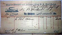
Robert W. Meriwether of the Faulkner County Historical Society wrote: After stopping at Natural Steps to take on fuel wood, the "Hallie" was proceeding upstream.
Suddenly a "terrific volley" of shots was fired at the steamer from behind rocks along the northern (eastern) bank of the river near Palarm.
One stray bullet pierced the supply pipe between the vessel's boiler and engine, thus cutting off its power, and the boat drifted downriver, out of gun range, and lodged on the southern (western) shore.
We invited the attention of General Nix to our discovery and after making a thorough examination, he pronounced the ruins to be unquestionably those of a very ancient raised Fort.
Every evidence existed corroborative of the fact, that away back in the past centuries, there had been an important Fortification at this place, and that there had been a terrible fight engaged in, either at its capitulation and destruction, or at some time previous.
In the immediate vicinity of the Fort, on a high elevation and far above any possible chance of overflow, there was to be seen a large excavation, now become a pond, grown up with "Menockonock" weeds and other water plants.
Inside of the walls, while plowing, we found great quantities of lead that had been melted, and also an immense Indian Axe of solid stone, perfect in form, save that the handle had been broken off.
This was a very interesting relic, and affords room for much thought and conjecture, as it was of extraordinary size, and uncommon shape, being four times as large as anything of the kind we had ever seen before or since.
I remember the weight distinctly, as Chandler carried it to Little Rock and sold it to Joseph Henderson, a merchant, who was a brother-in-law of Chester Ashley, and received therefor 77 one pound bars of lead.
It is a matter of history that "De-Soto" Hernando de Soto (explorer), passed through this identical country in his search for the "Golden land".
Several smaller sawmills called "gopher mills" operated in the area, and the timber industry, along with farming, provided the first major work for early residents."
[citation needed]Pinnacle Realty, Inc. was started in Natural Steps in 1974 and continues to sell real estate in the area.
[citation needed]The old Methodist Church burned to the ground, in the late 1940s, during a volunteer clean-up day at the Natural Steps Cemetery.
"The Fulk family, who owned the largest tract, including Pinnacle Mountain, also supported the plan to establish it as a state park."
The cone-shaped peak was first mentioned in the book, A Journal of Travels into the Arkansas Territory During the Year 1819, written by naturalist Thomas Nuttall.
Beginning in 1822, the local "Natural Steps" provided a convenient stop for Little Rock visitors to disembark for their hike to the mountain.
The park provides environmental protection and conservation for a relatively unspoiled tract of hills, forests, and waterways near a growing metropolitan area.
Also available are educational tours, self-guided trails, wayside outdoor exhibits, four major vistas, and opportunities for natural solitude.
The park visitor center overlooking the Arkansas River includes exhibits, A/V programs, a meeting room, and gift shop.
A century later, June 27, 1976, the same lodges came by boat and car for a similar ceremony, followed by burial of a time capsule that was to be opened one hundred years hence.
"The old story goes that Jesse James and his gang spent the night, in Natural Steps, and robbed a stage coach in Benton, on the road to Hot Springs, the next day."
But before his death, Gustavus and Martha decided to wed at their favorite meeting spot, at the top of the natural steps, overlooking the Arkansas River.