Navajo National Monument
It features a visitor center with a museum, three short self-guided trails, two small primitive campgrounds that are free to the public, and a picnic area.
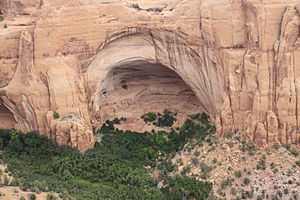
Rangers guide visitors on free (3-5 hour long) tours of the Betatakin cliff dwellings and on 17 mi (27 km) roundtrip back-country hikes to the Keet Seel.
[4] Keet Seel or Kiet Siel (Kįtsʼiil), which stands for "broken pottery scattered around"[5] in Navajo, is a well preserved cliff dwelling of the ancient Ancestral Pueblo people located in a branch of the Tsegi Canyon in the Kayenta region.
The site of Keet Seel was known to resident Navajos in the area for decades or longer prior to the first Europeans arriving in 1895 (the Wetherill brothers).
Originally part of a ranching family from Colorado, the Wetherills' keen interest in the Ancestral Puebloans led them to pursue numerous expeditions into the heart of the Kayenta region, largely uncovering a number of sites that had remained undiscovered to Anglos until then.
Later in their careers, the Wetherill brothers were largely involved in efforts for the preservation and protection of the sites that made up Navajo National Monument.
By living in these caves, and not on the mesas or the canyon floors, they were able to use this land towards agricultural production to ensure their success in this high elevation, desert environment.
In marked contrast to earlier constructions and villages on top of the mesas, the cliff dwelling of Navajo National Monument reflected a region-wide trend towards the aggregation of growing regional populations into close, highly defensible quarters during the mid to late 13th century.
Although many archaeologists agree that there is a definitive and sharp exodus from this region in the Southwest, there has been considerable debate on the determining factors that forced people to migrate out of this area.
Archaeologists have determined that there was a distinct decrease in the amount of annual precipitation between AD 1276 and 1299, a period of time that is now referred to as the "Great Drought".
There is evidence later in the record to suggest the beginning of an episode of deep arroyo cutting, that would have damaged what was left of the usable agricultural land.
Regardless of their reasoning, near the end of the thirteenth century it's evident that the Ancestral Pueblo people migrated towards places with more stable and abundant water sources, suggesting that the agricultural land in this area had become unsuitable to sustain the population levels that once inhabited this spectacular cave site.