List of state routes in Nevada shorter than one mile
The Harry Reid Airport Connector is a limited-access roadway system located in Paradise, an unincorporated town in the Las Vegas Valley, Clark County, Nevada, United States.
Wendover Boulevard was originally part of U.S. Route 40 (US 40), which connected California to New Jersey via Nevada and Utah.
From there, it follows Washington Avenue eastward, traveling under the Union Pacific Railroad tracks to intersect Main Street.
[1][5] Located at the intersection of SR 578's eastern terminus are the Grant Sawyer Building (a southern Nevada state office complex), Cashman Center and Cashman Field (home to the Las Vegas Lights FC soccer team) and the Old Las Vegas Mormon Fort State Historic Park (the first permanent settlement in the Las Vegas area).
SR 594 began at Polaris Avenue as a six-lane city street, and extended easterly to meet Interstate 15 at a diamond interchange.
[7] The Nevada Department of Transportation (NDOT) removed SR 594 from its maintenance logs by the beginning of 2019,[8] and has begun the process of turning ownership of the roadway over to Clark County.
Located entirely within the downtown area of Las Vegas, it comprises a small section of Casino Center Boulevard.
State Route 602 begins at the intersection of Bonanza Road (SR 579) and Casino Center Boulevard near the downtown core of Las Vegas.
From there, the route heads south along Casino Center Boulevard, passing underneath the Interstate 11/U.S.
Prior to its being turned over to local control in 2011, the route encompassed the Sierra Street bridge over Interstate 80 near downtown Reno.
State Route 668 begins at the intersection of South Rock Boulevard and Hymer Avenue in an industrial business section of Sparks.
The route heads north from there along Rock Boulevard, passing underneath the Union Pacific railroad tracks and interchanging with Interstate 80 (I-80).
The route was once part of the Lincoln Highway, forming a major travel link between Carson City and Lake Tahoe.
[1][22] SR 705 is currently not directly connected to the remainder of Nevada's state highway system.
[1] Trails connecting Lake Tahoe with the Comstock Lode mining region near Carson City had been established in the mid-1800s, with the first wagon road route through Kings Canyon to the north having been constructed by November 1863.
From 1927 to 1928, aided by both state and forest highway funding, a graded two-lane road was constructed along the corridor of Clear Creek to connect Carson City to Spooner Summit, just east of Glenbrook on the eastern shore of Lake Tahoe.
[26] Clear Creek Road later became part of US 50, but was bypassed in the 1950s by the current four-lane alignment located a short distance to the north.
The Nevada Department of Transportation initially designated SR 705, from the current western terminus east to a Bureau of Indian Affairs water diversion box in Carson City, by January 11, 2000.
[27] By the beginning of 2006, the short portion with Carson City had been removed from state maintenance, resulting in the current highway segment in Douglas County.
The route followed a 0.22-mile (0.35 km) portion of Sloan Road that ran from the western Interstate 15 right-of-way east to Las Vegas Boulevard.
From there, the route heads easterly along Elks Point Road 0.475 miles (0.764 km) to its terminus at US 50 in Round Hill Village just south of Zephyr Cove.
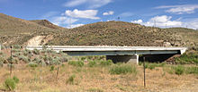
The route then traverses a viaduct (that passes over the Union Pacific Railroad tracks) before reaching its eastern terminus at an intersection with Grass Valley Road (SR 294)/West Haskell Street.
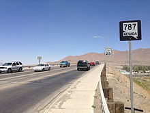
From the southern terminus of SR 787, Hanson Street continues easterly before ending at an intersection with South Highland Drive and Water Canyon Road.
From there, the route travels eastward 0.146 miles (0.235 km) along Dayton Valley Road, crossing over the Carson River.
It runs along Gage Road from the beginning of pavement eastward to State Route 824 (Day Lane).
SR 858 began on the west side of Interstate 80 and U.S. Route 95 at the Oreana Interchange (Exit 119).
The route crossed under the freeway and ended at the I-80 frontage road on the east side of the interstate.
[38] Established by 1935, that route traveled from the Oreana area east and north to Mill City via Rochester.
SR 880 starts at the beginning of state maintenance along Wedekind Road, just east of the Wildcreek Golf Course at the intersection of Malapai Way, near where the Orr Irrigation Ditch crosses the roadway.
The route then turns southeast on Farr Lane to come to its eastern terminus at an intersection with Pyramid Way (SR 445).