Nevado del Ruiz
Volcanic activity at Nevado del Ruiz began about two million years ago,[5] during the Early Pleistocene or Late Pliocene, with three major eruptive periods.
The volcano usually generates Vulcanian to Plinian eruptions, which produce swift-moving currents of hot gas and rock called pyroclastic flows.
The impact of such an eruption is increased as the hot gas and lava melt the mountain's snowcap, adding large quantities of water to the flow.
On November 13, 1985, a small eruption produced an enormous lahar that buried and destroyed the town of Armero in Tolima, causing an estimated 25,000 deaths.
The volcano continues to pose a threat to the nearby towns and villages, and it is estimated that up to 500,000 people could be at risk from lahars from future eruptions.
Today, the Nevado del Ruiz volcano is constantly monitored by the Colombian Geological Survey via the Volcanic and Seismic Observatory of Manizales.
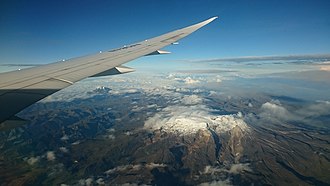
As late as 12,000 years ago, when the ice sheets from the last glacial period were retreating, they still covered 800 km2 (300 sq mi).
[8] During the past 11,000 years, Nevado del Ruiz passed through at least 12 eruption stages, which included multiple slope failures (rock avalanches), pyroclastic flows and lahars leading to partial destruction of the summit domes.
[5][8] During the past several thousand years, eruptions of the volcanoes in the Ruiz–Tolima massif have mostly been small, and the pyroclastic flow deposits have been much less voluminous than during the Pleistocene.
[26] The eruption caused lahars, which traveled down the valleys of the nearby Gualí and Lagunillas rivers, clogging up the water, killing fish and destroying vegetation.
[26] Beginning November 1984, geologists observed an increasing level of seismic activity near Nevado del Ruiz.
The extensive degassing of the magma caused pressure to build up inside the volcano, which eventually resulted in the explosive eruption.
[30] At 3:06 pm, on November 13, 1985,[31] Nevado del Ruiz began to erupt, ejecting dacitic tephra more than 30 km (19 mi) into the atmosphere.
[34] The eruption produced pyroclastic flows that melted summit glaciers and snow, generating four thick lahars that raced down river valleys on the volcano's flanks.
The lake's hot, acidic water significantly accelerated the melting of the ice; this effect was confirmed by the large amounts of sulfates and chlorides found in the lahar flow.
[36] They ran down the volcano's sides at an average speed of 60 km per hour, eroding soil, dislodging rock, and destroying vegetation.
Local authorities failed to alert people to the seriousness of the situation, with Armero's mayor and a priest both reassuring the populace after an ash eruption on the afternoon of November 13 and the consequent ashfall early that evening.
[8] Estimates show that up to 500,000 people living in the Combeima, Chinchiná, Coello-Toche, and Guali valleys are in danger, and 100,000 of these are considered to be at high risk.
[5][nb 2] Lahars pose a threat to nearby towns of Honda, Mariquita, Ambalema, Chinchiná, Herveo, Villa Hermosa, Salgar and La Dorada.
[45] As the Armero tragedy was exacerbated by the lack of early warnings,[41] unwise land use,[47] and the unpreparedness of nearby communities,[41] the government of Colombia created a special program (Oficina Nacional para la Atencion de Desastres, 1987) to prevent such incidents in the future.
All Colombian cities were directed to promote prevention planning in order to mitigate the consequences of natural disasters,[47] and evacuations due to volcanic hazards have been carried out.
[50] In 2006, heavy rains on Ruiz sent a mudslide down the Chinchiná River, killing nine children aged 12–19 on a scouting expedition near the volcano.
[51] During September and October 2010, the Colombian Geological Survey noted gradual increases in seismic activity near the Arenas crater.
Sulfurous odors and phreatic eruptions reported at Nevado del Ruiz prompted an alert level of Yellow on October 1.
[53] After seismicity continued to increase, the alert level was raised to Orange, and in April Nevados National Natural Park authority closed the reserve, fearing lahars and ashfall hazards.
[52][nb 4] On May 29, seismicity rapidly increased, and the alert level was restored to Orange because ash fell into more than 20 nearby communities.
The alert level was raised to Red, indicating an imminent major volcanic event, and an eruption 7.5 km (4.7 mi) in diameter took place on July 2, 2012, continuing intermittently until the end of August.
In November 2014, earthquakes were recorded, and volcanic ash was observed near the summit; ashfall reached local communities within a 19 mi (30 km) radius of Nevado del Ruiz multiple times each month until December 2015.
[55] In March 2023, seismic activity around the volcano dramatically increased, prompting the Colombian Geological Survey to raise the alert level from yellow to orange.
Families living in the area near the volcano were evacuated, and local schools transitioned to online classes; Los Nevados Natural Park was closed.