New Barn
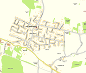
It is a compact residential area surrounded by open fields[1] which lies four miles southwest of Gravesend.
The greater part was in the parish of Southfleet, including New Barn House, New Barn Road, Southfleet Avenue and the western sections of Longfield and Fawkham Avenues up to the parish boundary, which bisected these roads in a north–south direction.
[2] Southfleet and Longfield were both part of Dartford Rural District and prior to that the Hundred of Axstane.
However the extent of the contiguous built up area of New Barn south of the former boundary, i.e. that part already in Longfield parish, can be seen on the Ordnance Survey map.
It is compact residential area surrounded by open, mainly farming, type land and separated by open land from the village of Southfleet and from Longfield to the south-west; it is separated from Istead Rise to the north-east and Meopham to the south-east.
[1] As one walks along Main Road, Longfield (B260) in an easterly direction there is on the left a bare hillside escarpment with along the main road a ribbon of development also on that side and on the other (south) side Longfield School and its playing fields.
If one continues along Main Road one comes to the separate village of Longfield Hill, which is on rising ground and in effect closes this end of the valley.
Here one is over the hill and the land and the road falls away to the Thames estuary and one has a very broad vista lying before one over parts of Northfleet and Swanscombe to the River, with the development of Istead Rise on a separate hill in the right foreground; there are a number of tall chimneys prominent in the landscape.