New England town
Towns date back to the time of the earliest English colonial settlement, which predominated in New England, and they pre-date the development of counties in the region.
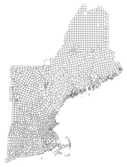
Town boundaries were not usually laid out on any kind of regular grid, but were drawn to reflect local settlement and transportation patterns, often affected by natural features.
In early colonial times, recognition of towns was very informal, generally connected to local church divisions.
Early town organization in Vermont and much of New Hampshire proceeded in a somewhat different manner from that of the other New England states.
This was very common in the mid to late 18th century—although there were towns which predated that period and were not part of this process in southeastern New Hampshire, such as Exeter.
In Massachusetts, nine municipalities (Agawam, Barnstable, Braintree, Franklin, Palmer, Randolph, Southbridge, West Springfield and Weymouth) have adopted Mayor-Council or Council-Manager forms of government in their home rule charters, and are therefore considered to be legally cities, but nevertheless continue to call themselves "towns".
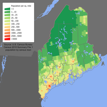
In addition to towns and cities, Maine has a third type of town-like municipality not found in any other New England state, the plantation.
On August 23, 1775, in order for more representation for the Revolutionary War, 36 towns in Massachusetts and 6 in Maine were incorporated, effectively eliminating the district meaning.
Most areas of New England never developed municipal forms based on the compact populated place concept.
At least one borough historically spanned more than one town: the borough of Danielsonville originally laid over parts of Killingly and Brooklyn, until the Brooklyn portion petitioned to be reorganized as a fire district and concurrently the Killingly portion was renamed Danielson by the General Assembly.
Cities actually developed earlier in Connecticut than in the other New England states, and were originally based on the borough concept.
In Vermont, if a village becomes a city, it does not continue to overlay its parent town, but breaks away and becomes a completely separate municipality.
[7] All three of the northern New England states (Vermont, New Hampshire, and Maine) contain some areas that are unincorporated and unorganized, not part of any town, city or plantation.
Typically smaller than a normal-sized town, these areas were known by a variety of names, including gores, grants, locations, purchases, surpluses, and strips.
No such areas exist today in Massachusetts, Connecticut or Rhode Island, but some remain in New Hampshire, Vermont and Maine.
As a result, Maine has developed more of an infrastructure for administration of unincorporated and unorganized areas than the other New England states.
The existence of this fallback probably explains why Maine has had significantly more towns disincorporated over the years than any other New England state.
In Vermont and New Hampshire, disincorporation has, in general, not been brought up for discussion unless a town's population has approached single digits.
Like civil townships, but unlike most incorporated municipalities in other states, New England towns do not usually represent a single compact populated place.
The Census classifications should not be understood to imply that New England towns are not incorporated, or necessarily serve a similar purpose to MCDs in other states in terms of governmental function or civic-identity importance.
In order to better fit their own purposes, the Census only counts cities and certain fully urbanized towns as "places" in its categorization.
In other towns, those with small built-up central villages, the Census designates one or more census-designated places (CDPs) and considers all other land to be parts of "minor civil divisions".
This classification is done only for the Census's own data analysis, and otherwise has no connection to the actual organization or legal status of New England towns.
That New England states, in general, regard cities and towns on equal footing, yet they are handled in two different ways by the Census Bureau, can be another source of confusion.
Many towns located in such areas do not contain any recognized CDPs and will thus be completely absent from Census materials presenting the population of "places".
In New Hampshire and Vermont, the Census Bureau treats each individual unorganized entity (township, gore, grant, etc.)
In a few cases in Maine where a township or gore does not border any other unorganized land, it is treated as its own MCD rather than being folded into a larger UT.
For a list of all New England towns and other town-level municipalities, see the following articles: Note: All population statistics are from the 2020 United States census.
A second non-coextensive city, Winsted, still exists on paper, but its government has been consolidated with that of the town of Winchester for many years, making it more of a special-purpose district than a true municipality.
The same classification is used for identifying Massachusetts cities on the list of New England towns and its attendant pages with historical census population statistics.