New York, Westchester and Boston Railway
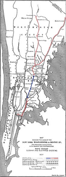
It ran from the southernmost part of the South Bronx, near the Harlem River, to Mount Vernon with branches north to White Plains and east to Port Chester.
[2] Starting in 1874 portions of Westchester County were made part of New York City, a process that was complete by 1898, with the Bronx in its current configuration.
In 1901, while the NYW&B still in receivership, the Harlem River & Port Chester Railroad (HR&PC) was incorporated to build a route from the Harlem River to Port Chester, parallel to the NYW&B route and the New York, New Haven & Hartford Railroad (NH) main line.
Meanwhile, the NYW&B emerged from receivership on January 14, 1904, and began acquiring additional real estate rights for its route.
In 1906 bankers Oakleigh Thorne and Marsden J. Perry bought the stock of the NYW&B on behalf of the Millbrook Company, a holding entity.
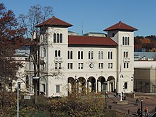
The stations, attractive cast concrete with marble interiors, used high platforms for faster passenger loading and unloading.
The extension from New Rochelle to Port Chester was built to a much more economical standard, as exemplified by wooden platforms and more modest stations.
[3][5] On August 3, through service commenced on the New York, New Haven and Hartford Railroad's Harlem River Branch to the Third Avenue Line.
The savings of not paying the high costs of using Grand Central were offset by the lower fares that the NYW&B charged.
The NYW&B's White Plains line ran about two miles (3 km) east of the Harlem Division of the NYC.
The Harlem Division served the settled towns and villages along the Bronx River and its commuter trains enjoyed the advantage of running directly into Manhattan.
Even the rapid transit connections available at Harlem River and East 180th Street were inconvenient compared to the direct service offered by the NYC and the NH to Grand Central.
Former New Haven General Manager Clinton L. Bardo was appointed as Trustee to try to turn around the fortunes of the ailing Westchester.
The NYW&B was forced to cease operating on the Port Chester line to enhance the revenues of the NH from its parallel service.
The sale of other assets, principally real estate, was complete by 1946, bringing the final end to the corporate entity.
Their pantographs were removed and the cars were hauled by a steam locomotive to bring workers from the city of Houston to the shipyards in Pasadena to build Liberty ships.
The NYW&B powered its equipment by overhead lines carrying 11,000 volts alternating current at 25 Hz, the same as the New Haven.
NYW&B's tracks ran parallel to the NH's tracks, serving four stations also served by New Haven commuter service,[citation needed] to just south of 180th Street, which was the site of the company's headquarters, shops, and yard, and a major transfer point to the New York City Subway.
From 180th Street the railroad ran on its own four-track right of way, serving six stations in the Bronx and three in Mount Vernon before its routes divided at Columbus Avenue.
However, after the new village of Elmsford (incorporated in 1910 from the Town of Greenburgh) voted against the NYW&B's presence on esthetic grounds, it was dropped from further consideration.
Another NH interests company, the Westchester Northern Railroad (WN), was chartered in 1910 to build a northward extension of the NYW&B from White Plains to Pound Ridge, with one branch to Danbury, Connecticut and one to Brewster, New York.
The NH would have discouraged running trains into Grand Central, since it paid a rental fee to the NYC for each movement into the terminal.
Large concrete bridge abutments remain at Hutchinson Boulevard in northern Willson's Woods Park in Mount Vernon.
Remains of the Columbus Avenue station in Mount Vernon, including the abutment on the north side of the NH line, are still in place.
A concrete block outbuilding, commonly referred to as "The Forge", is on the right of way in Ward Acres Park parallel to Broadfield Road.
The former Wykagyl station is part of a shopping center on the east side of North Avenue near Quaker Ridge Road.
The right of way west of the Remington Station to the Pelham border remains, paralleled on either side by residential streets (French Ridge and Sickles Avenue).
Although obscured by surrounding homes, the large stretch of railroad property can be viewed using satellite mapping sites online (40°54′51″N 73°47′48″W / 40.91417°N 73.79667°W / 40.91417; -73.79667 (Right-of-way north of Remington)).
The southbound I-95 exit and entrance ramps at Cedar Street in New Rochelle and the adjacent Memorial Highway access roads were built on the trackbed of the NYW&B's North Avenue station.
Prior to the highway construction, the fill west of the North avenue station had been removed to provide space for barracks-style housing for returning World War II veterans.