Nieuwleusen
To the west, provincial road N377 and highway A28 meet at De Lichtmis, the location of a former military bulwark which provided access to the north of the country.
The town has a northern and an older southern half (today called Nieuwleusen-Noord and Nieuwleusen-Zuid, respectively) separated by sports fields and facilities.
[4] The southern part has the Kerkenhoek area with the Grote Kerk (Great Church) from 1830, first built in 1660;[5] the former town hall; and the small Palthebos wood, once the possession of the Palthe family of clergy and landowners.
Rural cores and former hamlets that form part of Nieuwleusen include Den Hulst to the north, De Meele to the northwest and the Ruitenveen to the southwest.
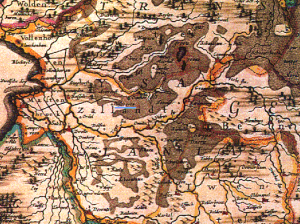
At the time, most of the area between Leusen, a village on the Vecht, and the Reest on the border with the province of Drenthe consisted of inaccessible peat moors.
The entire area of the Vechtdal, from Hasselt to Coevorden, is indicated as 't Veen (the Peat Moor) on a map by Abraham Goos from the early seventeenth century.
[7] Between 1640 and 1646, the nobleman Zweer van Haersolte built the havezathe (country house typical of Overijssel) Oosterveen here.
In 1809, Nieuwleusen-born nobleman and politician Baron Willem Jan van Dedem started construction of the Dedemsvaart canal through northern Overijssel, meant to facilitate the transportation of peat, which was being dug on a large scale in this part of the Netherlands.
The canal would eventually stretch from the Zwarte Water in Hasselt to the Vecht at Gramsbergen, cutting horizontally through the north of the province.
Just north of Nieuwleusen, as at other points where there were locks and bridges, the Dedemsvaart stimulated settlement alongside the canal.
It encouraged the growth of the hamlet of Den Hulst (known locally as Nulst), first mentioned in the early eighteenth century.
Like many municipalities, it applied for one in that year on the occasion of the construction of a new meeting hall for the Provincial States of Overijssel.
[13] In 1913, the first state college for female teachers of husbandry and housekeeping, called De Rollecate, was opened in Den Hulst.
The house De Rollecate, where the courses were taught, had been built around 1654–1655 in Vollenhove, and dismantled in 1821 by Van Dedem to be rebuilt on the bank of his Dedemsvaart canal.
The factory, which went on to produce famous Dutch bicycles throughout the twentieth century, was an important factor of employment in Nieuwleusen.
Notwithstanding Union's demise, Nieuwleusen remains industrially active because of the town's favourable location close to Zwolle.
A new square lined by combined shopping and residential units was created alongside the Backxlaan in the south in 2007.
This association opened the Palthehof Museum of local history in 1998, which features permanent and temporary exhibitions about aspects of the town's past.
Nieuwleusen has a cluster of outdoor and indoor sports facilities which separate the northern and southern halves of the town.
[21][22][23] The town lying in Overijssel rather than in the bordering province of Drenthe, however, its dialect (traditionally called simply Ni'jlusens or plat) is often seen as Sallaans rather than Drents.
The dialect singer Aalt Westerman from Nieuwleusen, for instance, is billed as 'the troubadour of the Sallaans language'.
[27] The dialect is used marginally in publications, for instance in the magazine of the Historical Association Ni'jluusn van vrogger.
Zo kwamp Klaos dan met zien negotie bij een gezin waor ak de name niet van numen wille.
Er ging een schip deur de Dedemsvaort en het mag dan wel toevallig wezen, mar opiens zei Klaos tegen de vrouwe: "Dreit oe ies umme en leest ies wat op det schip stiet".
Standard Dutch translation: Zo kwam Klaas dan met zijn handelswaar bij een gezin waar ik de naam niet van wil noemen.