Niger Delta Basin (geology)
[2] It is composed of several different geologic formations that indicate how this basin could have formed, as well as the regional and large scale tectonics of the area.
The Niger Delta Basin lies in the south westernmost part of a larger tectonic structure, the Benue Trough.
The other side of the basin is bounded by the Cameroon Volcanic Line and the transform passive continental margin.
The sediment provenance from the onshore highlands which feed into the delta control the mineralogy of the grains.
There is a section of rock in this basin from the middle to late Cretaceous which is poorly understood due to its significant burial depth.
It is composed of thick shales, turbidite sands, and small amounts of silt and clay.
The Akata Formation formed during lowstands in relative sea level and anoxic conditions.
The main method of deformation is gravitational collapse of the basin, although the older faulting and deformation in the basin are related to the continental breakup and rifting of the African plate and South American plates.
Basin inversion forms anticline structures, which serve as a great oil trap.
[1] Basinward dipping reflectors are a common feature of extensional type rift basins.
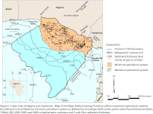
[3] The Niger Delta is the twelfth largest province in the world by known oil and gas resources.
The entire system is predicted to contain 34.5 billion barrels of oil and 94 trillion feet3 of natural gas.
[6][7] The delta covers 20,000 km2 (7,700 sq mi) within wetlands, formed primarily by sediment deposition.
Home to 20 million people and 40 different ethnic groups, this floodplain makes up 7.5% of Nigeria's total land mass,[8] and is Africa's largest wetland.
[10] The delta is well endowed with natural resources and the surrounding ecosystem contains one of the highest concentrations of biodiversity on the planet.
In addition to supporting abundant flora and fauna, arable terrain that can sustain a wide variety of crops, lumber or agricultural trees, and more species of freshwater fish than any ecosystem in West Africa.