Ninemile Canyon (Utah)
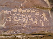
The rock art, shelters, and granaries left behind by the Fremont make Ninemile Canyon a destination for archaeologists and tourists alike.
The discovery of rich deposits of natural gas deep beneath the West Tavaputs Plateau has brought an influx of industrial truck traffic since 2002.
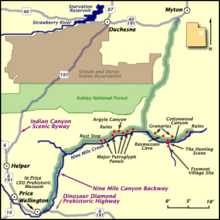
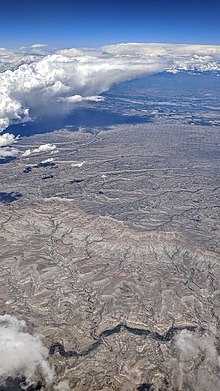
[2] Ninemile Canyon runs roughly southwest to northeast, with numerous winding turns, just to the north of the Book Cliffs, and south and east of Ashley National Forest.
[5][6] In contrast to the purely hunter-gatherer cultures that surrounded them, the Fremont practiced agriculture, growing corn and squash along the canyon bottom.
Compared to other Fremont areas, relatively little pottery is found in Nine Mile, suggesting that beans, which must be boiled for hours to become edible, were not an important part of the local diet.
[3]: 45 The Fremont left irrigation ditches and earthen lodges on the canyon floor that could be seen as late as the 1930s, but are no longer visible after generations of modern cultivation.
Most of the stagecoach, mail, freight, and telegraph traffic into the Uinta Basin passed through Ninemile Canyon until after the arrival of the Uintah Railway around 1905.
[10] Rock art and other ancient artifacts are now protected by law and, although enforcement is difficult, outright looting and malicious vandalism are largely a thing of the past.
Carved and painted mainly on weathered sandstone panels, the images are susceptible to erosion, which is accelerated by touching[3]: 87 and airborne dust.
As in many rural areas of the Western United States, land in the canyon is a patchwork of public and private property.
Since 2002, the Bill Barrett Corporation, in cooperation with the BLM and private landowners, has been pursuing a natural gas exploration project on the West Tavaputs Plateau in and around the canyon.
[11] Bill Barrett Corporation has spent some $2 million on improving area roads, and the complete project, if approved as planned, could create as many as 1000 jobs.
[13][14] Government involvement in the project has been controversial, drawing complaints from conservation groups that not enough is being done to protect natural and cultural resources.
[11] A 2007 study, commissioned by the BLM and paid for by Bill Barrett Corporation,[13] found that the dust that lands on a rock art panel created "a very serious conservation problem.
"[17] In 2004, due to concerns about energy development and increasing recreational and tourist traffic, Ninemile Canyon was named on the National Trust for Historic Preservation's list of America's Most Endangered Places.


March 2008