North Holland
North Holland (Dutch: Noord-Holland, pronounced [ˌnoːrt ˈɦɔlɑnt] ⓘ) is a province of the Netherlands in the northwestern part of the country.
In the 17th and 18th centuries, the area was part of the province of Holland and commonly known as the Noorderkwartier (English: "Northern Quarter").
[8] The province of North Holland as it is today has its origins in the period of French rule from 1795 to 1813.
Holland was split up into five departments named "Texel", "Amstel", "Delf", "Schelde en Maas", and "Rijn".
This reorganisation had been short-lived, but it gave birth to the concept of breaking up Holland and making it a less powerful province.
One of the ministers on the constitutional committee (van Maanen) suggested that the old name "Holland and West Friesland" be reintroduced to respect the feelings of the people of that region.
Even though the province had been reunited, the two areas were still being treated differently in some ways and the idea of dividing Holland remained alive.
The impetus came largely from Amsterdam, which still resented the 1838 relocation of the court of appeal to The Hague in South Holland.
After the Haarlemmermeer was drained in 1855 and turned into arable land, it was made part of North Holland.
[9] This has been positively received by the First Rutte cabinet, for the desire to create one Randstad province has already been mentioned in the coalition agreement.
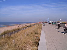
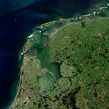
More than half of the province consists of reclaimed polder land situated below sea level.
After the dissolution of the Netherlands Antilles, three islands in the Caribbean: Bonaire, Saba, and Sint Eustatius, were offered to join the province.
They are, in order of size, Amsterdam (in terms of population this is also the largest municipality in the Netherlands), Haarlem, Zaanstad, Haarlemmermeer and Alkmaar.
Another seven municipalities have a population between 50,000 and 100,000 inhabitants (Hilversum, Amstelveen, Purmerend, Hoorn, Velsen, Den Helder and Dijk en Waard).