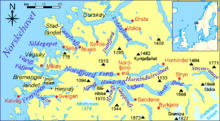
Nordfjorden (Vestland)
It flows through the municipalities of Stryn, Gloppen, Stad, Bremanger, and Kinn, and it is the central feature of the entire Nordfjord region which makes up the northern third of the county.
The fjord starts as runoff from the Jostedalsbreen, Europe's largest mainland glacier, in the east and it flows west, emptying into the ocean just south of the Stadlandet peninsula.
The fjord reaches a maximum-depth of 565 metres (1,854 ft) near the mouth of the Eidsfjorden and also by the village of Bryggja.
There is an electric ferry from Anda to Lote as part of the European route E39 highway, using 75 kWh per crossing.
Some of the notable population centers along the fjord include the town of Måløy (near the north side of the mouth in Kinn), the villages of Bryggja and Totland (in Stad); Rugsund, Davik, and Ålfoten (in Bremanger); Kjølsdalen, Stårheim, Nordfjordeid, and Lote (in Stad); Sandane and Gimmestad (in Gloppen); and Randabygda, Utvik, Innvik, Roset, Stryn, Olden, and Loen (in Stryn).