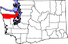
Marrowstone, Washington
It was given the name "Marrow-Stone Point" in 1792 by the British explorer, George Vancouver, in describing the area's hard, clay-like soil.
[5] According to the United States Census Bureau, the CDP has a total area of 6.3 square miles (16.4 km2), all of it land.
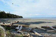
Other notable features include East Beach, a sandy beach at the northern end of East Marrowstone Road and Scow Bay/Kilisut Harbor, which separates Marrowstone Island from its western neighbor, Indian Island, a Navy ammunition depot.
A short bridge joins the western side of Indian Island to the mainland of Jefferson County.
Flagler Road (SR 116) runs along the western edge of Marrowstone Island, which is primarily low-lying.
On Memorial Day weekend, island residents bring their tractors to parade them in front of the Nordland General Store.
The neo-pagan Aquarian Tabernacle Church performs a modern Eleusinian Mysteries play at Fort Flagler over Easter weekend each year.
Fort Flagler, a Washington state park, is situated on 784 acres (314 hectares) at the northern end of Marrowstone Island.
Kinney Point State Park comprises 76 acres (310,000 m2) at the south end of the island.